0.1 Foreword
0.2 INTRODUCTION
1. TERRITORIALIZATION: IDEA OF WORLD
2. DETERITORIALIZATION: THE IDEA OF GOD
3. RETERITORIALIZATION: THE IDEA OF MAN
4. GEOPHILOSOPHY OF PREMODERN OF CENTRAL BALKANS
5. Summary

Foreword
Characteristic motifs of Van Gogh’s painting are landscapes with cypresses and a sky with more suns. Some of these paintings he worked on its “psychotic phase” during hospital treatment in Provence, a upon completion of the painting Starry Sky (1889), he wrote a letter to his brother: “The eternal question is, have we been given to know only one before death hemisphere. As for me, there is no answer, but the stars always make me they encourage thinking.” This statement has a deeper meaning if you look at it in a broader context. Russian scientist A. Kolmogorov (1903-1987) deepened is a mathematical understanding of turbulence and energy decline turbulent fluid at a certain distance? They confirmed this image of a “whirlwind of distant clouds” made by space the Hubble satellite (2004), which reminded scientists of Van Gogh’s image, so they then studied the brightness in his paintings. They determined the existence of a “pronounced pattern of turbulent structures fluid “, which is very close to Kolmogorov’s equation, hidden in many of Van Gogh’s paintings. When scientists digitized its images and determine the variation of brightness between any two pixels, curved lines appeared due to pixel separation. Based on that, they concluded that the images were from the psychotic phase of Van Goga behaves remarkably similar to fluid turbulence, and yes there is some connection between his suffering (psychosis) and one of the most difficult concepts[1] which nature has placed before man, and that is the question the origin of the cosmos.
The connection between philosophy and geography is strengthened by interdisciplinary one’s area, and during the twentieth century. several concepts with the prefix “geo” were created predominantly for non-geographic disciplines. The first was geopolitics, formulated by R. Kjelen in the book The State as a Form of Life (1916). He developed the basic postulates of geopolitics using by analogy F. Ratzel, who compared the state to an organism which needs space to grow. He considered the state to represent the concentration of a specific force acting internationally space and to implement the policy it is through its institutions called geopolitics. Another example relates to the term geohistory, and which was developed by the most prominent historian of the French school Analy, F. Braudel. This term refers to broad socio-spatial structures (like the conditions of capitalism), which are repeated throughout the everyday social life in different forms and spaces and have a long duration. Braudel thought that geography helps us see things in the long run of themselves, which he describes as over imperceptible movement of history. On this matrix he considered the history of capitalism, and social and physical geography helped him is to avoid teleological narratives in favour of complex spatial one’s conditions that have a long historical duration. Therefore, geohistory is used geography, not as a long-term goal but as a means to achieving the goal. The third example concerns the term geopsychiatry, which was developed by the Portuguese psychiatrist F. Tosquels, through adaptation milieu, in a French psychiatric hospital. Specificity these therapies refer to adapting to socio-spatial connections in the local community for psycho-therapeutic purposes. It’s Tosquels claimed that “mile therapy” allows the patient to immerse in the environment community, not to hide behind the walls of the institution. Because it’s a hospital integrated into the life of the local community, thus being coordinated the work of psychiatry and traditional local activities. With a spatial turn over the triad of hospital-insane asylum-prison, we came to M. Foucault. He is through numerous spatial metaphors emphasized specialization, ie. spatial dimension (situational and locality), which significantly contributed to the “reaffirmation of space” or a spatial turn in the social sciences. It’s from this derived the term geoepistemology, which expresses the hypothesis of knowledge that is formed spatially and that “only specialized knowledge they can have the power of legitimacy – use – practice, as well as yes they are created thanks to power / knowledge and discourses”. In the end, with these geo-disciplines should be supplemented by geophilosophy, which is the end the twentieth century was constituted by the French philosopher J. Deleuze and psychoanalyst F. Guattari[2]. They made the most complete elaboration of the philosophical meaning of this term, and according to which geophilosophy explores the complex relationships between opinion, territory and the country itself, using spatial concepts to reinterpret philosophical settings.
The structure of the book follows the chronological evolution of the geographical opinions and retains the form of a geohistorical narrative. Chapter one it is called the Idea of the World because it reflects the meaning of the efforts of the ancient’s philosophers-geographers to know the shape and size of the Earth, to discover its position in space and to find out what is around them. It is presented through a description of the origin and millennial development of the fundamental philosophical ideas (materialism, idealism, dialectics and determinism) and their progenitors, from Anaximander to Ptolemy. The second chapter is called The Idea of God, and it reflects constant questioning about the way the world came into being and its structure. This was achieved during the millennial period of the Middle Ages, on the basis of different dogmas and within the framework of scholasticism, and which ones are the best reflects the Aristotelian-Ptolemaic picture of the world. The start this period was marked by the teachings of St. Augustine, and hints of the end was hinted at by Enrique the Sailor. The third chapter is called the Idea of a Man. It points to the renaissance and the main ideas of the new age, in which man will become the central motive, and human thought a basic philosophical question. Precisely in that world and on the basic’s universal ideas, cosmogonic-cosmological representations will be overcome and a framework for the emergence of scientific geography will be formed. The beginning of this period was the teaching of Copernicus, and the completion was marked by the teachings of Kant. In the end, if it is a starting point hypothesis contained in the assessment that geographical opinion originated from world of philosophical ideas, then the fourth chapter can be considered a kind of synthesis of this book. It is given historically and geographically review of the development of Bosnia and Herzegovina during the premodern, based on matrix of basic geophilosophical concepts. It is also important to mention the symbolic appearance of the title page book, which is not just a set of three vaguely connected segments (photograph of night sky, Copernicus’ model of the heliocentric system and details from Van Gogh’s painting Starry Sky), but it is cosmogonic representation of the world, as the central subject of research in this book.

In this hermeneutic way, it is rounded out by cause-and-effect connection between the mentioned non-geographies: geopolitics, geohistory, geropsychiatry, geoepistemology and geophilosophy. This all looks like so complex, and I just wanted to point out the similarities between art performances by Copernicus and Van Gogh. Apparently, because of similar one’s coincidences and this book was written. The author is grateful to the reviewers, publisher and editor books. The author owes special gratitude to his colleagues from the Faculty of Philosophy, East Sarajevo. They contributed useful suggestions to this the book gets better. All photographs in the work are copyrighted, and for some which they are not, the source is cited.
[1] Abstract philosophical ideas that characterize spatial processes. Every concept consists of several internal elements that act in direct connection with each other and create new ones a concept whose meaning consists of interconnected elements. On the one hand, the concept is “multitude”, a system composed of complex inputs, outputs, and processes (similar to rhizomes or maps). On the other sides, the concept has a singularity because its meaning is specific to its particular constitutive elements
[2] The term geophilosophy was only used for the first time in their latest book, “What is philosophy? (1995).
INTRODUCTION[1]
The main goal of this book comes down to understanding the origin and development geographical thinking, and the challenges and solutions it provides us geography for two and a half millennia. Those challenges are during these periods were variable, especially when viewed from today perspectives, because geography studies the different relationships between population and nature. In doing so, the emphasis is on exploring the place, space and natural environment with the obligatory questioning: where, what, how and why. The content of this geographical synthesis is formulated with the ambition to they also realize three additional goals. First of all, it is an attempt to describe man fascinated by new knowledge, which forced him to explore it earthly which is beyond its horizon. In this way the man discovered New worlds, which have a formal origin in antiquity period, and are still relevant today. Hence their philosophical vocabulary we can call it a search for an idea of the world. Also, a constant desire for knowledge of the origin and mode of origin of the cosmos, but also his structure, made the man look up at the sky. Craving for with knowledge and looking for an answer, he asked himself: “How did it all start”? The term cosmogony this goal can be defined as the idea of God. In the end, that is also a desire to show the development of geographical thought on its own the path of development and perception, in all its fullness, intertwining with others natural and social sciences. Also, the dichotomy of geography to two separate parts (natural and social), it constantly reminds us that we should also look for the idea of man, because it is during this period was the same guiding star – philosophy.
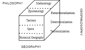
The elaboration and realization of such complex goals, it was used is a methodological approach that involves the application of the specific model[2] geographical opinion. He will allow that geophilosophy presents on simple enough, understandable and a representative way, and that means also complex enough, how to clarify the essence of this views of the world. He was created (coherently) from a set of more perspective, and through which geographers analyse the world[3]. This model is based on the existence of three perspectives within which there is a set of layers. Based Deleuze’s traditional interpretations of this term, as unity of the three great strata (physic-chemical, organic and anthropomorphic), and which unite very different “Forms and substances”, and various “codes and environments”, are created different “types of formal organization” and different “modes substantial development”.
As a kind of analogy like this stratification, we can think about the elements of the geosphere, and on creating a model on the basis of which it will be studied geographically thinking during premodern. The first perspective we could mark as geographical, within which, in addition to space and territory, there is also a process of historical-geographical development, which is shown chronologically. The second perspective is represented by philosophy[4] , and relates to an understanding of the connection of this process with the philosophical teachings of which this geographical direction originated, ie. general philosophical framework in which developed geographical ideas. It represents a third perspective geophilosophy, which includes “unity of opinion, territory and countries”. This level of knowledge can be simply represented by the term circuit (assemblage), which has two components (horizontal and vertical axis), through which various aspects of spatiality are expressed. A useful guide to this new theoretical framework or, more modestly that is to say, a new set of conceptual tools is provided by geophilosophy, which should be seen as part of a “complexity theory”[5]. The focus will be mainly on the elements of space, and the main components are: territorialization, deterritorialization and reterritorialization.
Geography
Geography also studies the ways in which nature affects society. Therefore, there is a constant question of both raw materials and social forces affect the progress of human society and its culture. It affects that the interaction of society and nature creates complex interrelationships relationships, because what was once a causal relationship, mostly in one direction, becomes an equally causal connection in the reverse direction.
In addition to the geographical distribution and characteristics of the population and objects, it is also important to understand the processes, systems and mutual relationships, which affect their meanings. This also applies to perception specific patterns of behaviour, which are created by people they physically create where they live and work. At the same time, study of the natural environment has both a natural and a social dimension, provided that human activity affects these resources as well as their mutual connection with different consequences (social, economic, political and cultural). From such a broad definition of the subject itself geography, its focus on how to shape and change is visible social forms, but also the accelerated transformation of the natural middle. Consequently, from the primordial natural environment under the influence man, human “materialized” forms are created that create environment and make these “sedimentary layers of socialization” of some with others, as a consequence, create a complex natural and social landscape.
Human activity continuously creates a new context in which nature becomes a social construction[6], in the sense of man social and economic forces, which reshapes space through intervention of ideas and application of different discourses. Because that, Peet (1998: 1-3) emphasizes that understanding this system of relationships requires from geographers sophisticated knowledge of natural and social sciences, as well as the ability to find ways to combine the two elements: on the one hand, it is knowledge of methods, and on the other, it is excitement insight into both aspects of knowledge (nature and society). In that manner, the synthetic core of geography becomes the study of interrelationships nature and society, with differences within the natural environment they become a source of cultural differences, and consequently, it has led to changing the methodological framework of geography. Simplified, Grcic (2009: 66) sees the essence of the subject of geography in the processes of development and the mutual relations of man (society) and nature, from which they arise universal and eternal questions of science and philosophy. He thinks it is real geographical space open book, which is “easy to read, but difficult to understand “, because in order to understand it, we need to go deep into the relationship and processes in the relations of nature and society. Because of this, the geography defines it as a field of science, which singles out a kind of spatial systems “Linked by specific links, which unites them into complex regions, both differentiated by components and integrated natural and social processes”.
To know the outlines and to sense the complexity of origin and development geographical thinking, it is necessary to adopt basic scientific ideas about it (from cosmogony and cosmology to geography) and understand the dynamics of that process. Its evolution clearly indicates two periods marked growth and scope of geographical knowledge (ancient and modern) and period of “great stagnation” (Middle Ages). To avoid extensiveness descriptions and lexicographical approach, the subject of this perspective there will be a conceptual focus on the historical-geographical narrative of elected geographical schools and representatives, respecting their significance and historical duration. It is also necessary to stay on the basic characteristics of geography – specialization (space and territory) and the basic goal of any geographical study – the population.
Space as a term has a long tradition of use, from antiquity of cosmogonic representations (Aristotle), to the modern rise scientific opinion. That rise began with methodical doubt (Descartes), and it was continued by the sharp opposition of the two concepts. The first is absolute space, which was advocated by Newton (space as container for objects, defined by coordinates x, y, z), and others is a relative space, advocated by Leibniz (denies reality space independent of the mind, ie. considers it the result of a relationship between things). A kind of overcoming of this dichotomy, temporarily, will be overcome through the transcendental aesthetics of space and his metaphysical examination (Kant), i.e., by what it implies Kantianism as a conception of space. The notion of territory has relatively newer meaning and gained full significance after Westphalia peace[7], which strongly expresses the political significance and power of the social space. Basically, the notion of territory had a limited meaning spatial range, primarily in the domain of expression of a particular identity, ie. represented the limit of sovereignty, jurisdiction, administration and citizenship.
An unavoidable geographical issue that has always existed in the background essential global thinking, related to demo geography, ie. to the population of the world. Let’s note right away, that’s too much a complex problem to be considered in detail in this synthesis, but it is necessary to give basic indicators of its dynamics (growth). During the observed period, the growth of the world population had balanced and very slight growth, which is in absolute terms ranged from 200-300 mil. (At the beginning of the new era, only the Roman Empire had about 50 mil. inhabitants), 1700 the population reached 600 million, a one billion[8] 1804. To understand the complexity of the concept of growth population, it is necessary to enter exact indicators in this description, an according to which this growth is performed:
Table 0.1: Cumulative growth law
| The annual growth rate of …. | Equal to the generation growth rate (30 years) of … | After 30 years multiplication by coefficient … | After 100 years, multiplication by coefficient … | After 1000 years, multiplication by coefficient … |
| 0,1% | 3% | 1,03 | 1,11 | 2,72 |
| 0,2% | 6% | 1,06 | 1,22 | 7,37 |
| 0,5% | 15% | 1,16 | 1,65 | 147,00 |
| 1,0% | 35% | 1,35 | 2,70 | 20.959,00 |
| 1,5% | 56% | 1,56 | 4,43 | 2.924.437,00 |
| 2,0% | 81% | 1,81 | 7,24 | 398.264.652,00 |
| 2,5% | 110% | 2,10 | 11,80 | 52.949.930.179,00 |
| 3,5% | 181% | 2,81 | 31,20 | … |
| 5,0% | 332% | 4,32 | 131,50 | … |
We can now determine exactly the rates of growth in the observed period, or estimate the population based on average growth rates. This is especially important due to current trends in global growth population (1.1%)[9], which increases over one generation > 1/3, and if would maintain this trend, 2120 it would be magnified 2.7 times (that would be about 20.7 billion inhabitants). When we compare this data with average growth rate in the period 0-1804 (< 0.1%), the topicality is clear these issues. Observed historically and geographically, at growth rates 0.1% of the world’s population is 200 (300) million, for the year 1000. has grown at 574 (816) mil. population, and with a rate of 0.2% that number would be an incredible 14.74 (22.11) billion. Todaro and Smith (2006: 250) accept estimates that in the period up to 1650. world population grew at an average rate of 0.04%, and then the growth increased many times: until 1750 (0.29%), and then until 1850 (0.45%). On the challenges of world growth population was pointed out by Malthus (1798), and the current drama of this process was strongly emphasized by the study
Growth of Limits[10] (1972). Now more clearly, the challenges of world population growth were predominantly determined and the character of the interaction of geography and other social disciplines.
Philosophy and geography
To clarify the essence of the processes that occur in the interaction of nature and society, the level of description of these processes alone is not enough either consequence of their action. They are visible on the earth’s surface and are recognized, in the spatial sense, as terms: space, place, land and land (topographic and cultural determination), region, living middle, landscape. It is necessary to understand their transcendental meaning (according to I. Kant, transcendentally represents knowledge which he is not preoccupied with objects at all, but with our way of knowing objects), i.e., discover the levels of that knowledge. It stops from this point geography, and philosophy begins, ie. dealing with epistemology theory cognition. In the desire to point out the significance and closeness of certain philosophical and geographical ideas (from Anaximander to Kant), it is pointed out
on the historical development of geographical thinking. The structure of this part, which has a chronological-evolutionary dimension, well describes the name of one of the most important journals in this field (Philosophy and Geography: Space, Place and Environmental Ethics[11]). It is necessary to do something specific here terminological clarification, not only because of the terms that define this title already because of the methodological framework of the research in this book.
This geographical synthesis implies a certain degree of understanding philosophical terms, so that the subject of the paper will come out of a purely geographical field, and with the ambition to know the wider philosophically a framework in which various geographical ideas have developed throughout history.
The term ethics is derived from the Greek words ethikos and ethos, and which have the meaning of habit, custom. It is an area of philosophy that encompasses systematization, defence and recommendation of the concept of correct and misconduct, which can be interpreted as the science of morality. Sublimating the notions of morality and intelligence leads us into the world as well ontology, in which Plato traced the path to the “cause and source of each.” beings and truths, of every reality and goodness”. It is for him a god, a father, forever he will also be the creator (demiurge), who created the cosmos and the whole visible the world, man and all living beings. This character of cosmogonic representations from the ancient world it would later be transferred to the early Christian learning and becoming part of dogma, e.g., notions of eternal life or immortality of the soul. Basil the Great will deviate from the Hellenic teachings on creation based on “timeless necessity (demiurge, logos, One) “through the vision of the created world as the will of God and man of life in freedom.
The terms space and environment are predominantly geographical determination and concretization of geographical reality, and their specifics we recognize as regional differences. They originally originated from physical and environmental characteristics and are a valuable resource for regional geography, which, according to Claval (1998: 28-30), creates a kind of “historical record of social and natural differences.” That’s why these concepts are understood as ecological wholes, which are social activities differently transformed throughout history. It is important to point out immediately the meaning of the first term (space), through which the epistemological is broken basis of geography. Geographical knowledge has always been based on cognition space and its cartographic representation. Expanding this knowledge, it depended on the applicability of the various innovations that led towards creating new conceptions of space. During the historical development geography, the notion of space is modified by specific connections between “Power, knowledge and geography”. According to Gregory et al. (2009), XIX century there was an age in whih time dominated, while the XX century marked space, during which modern became postmodern. It is marked as a spatial turn in a wide range of humanities and social sciences, where the conceptualization of space represented a watershed between geographical directions.
Table 0.2: Conceptualization of space and development of scientific geography
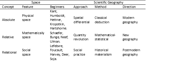
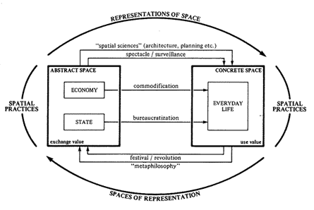
Contribution to the scientific foundation of modern geography (modern) marked the concept of space, which developed along the historical verticals: Descartes, Newton, Leibniz, Kant. Indications of this process are described are in the previous chapter, and a more detailed description follows in the chapters about these greats. Humboldt and Hettner they expanded the theoretical conception of the term absolute space, a thus modern geography, and the final form was given to it by Hartshorne by introducing the term spatial differentiation (Nature of Geography, 1939). The notion of space and its philosophical interpretation will become the basis for the development of different geographical views to reality in the second half of the twentieth century, when two more occurred changes in the conception of space, which also represented dividers within geography itself. Schaefer [1959) began is a quantitative revolution in geography (the concept of relative space), as a theoretical basis for a new geography. For clarification the new concept of space required more complex geometry, which introduced into the spatial analysis (basic methodological procedure) process abstraction, as a precondition for the transition from physical to mathematical space. During this phase in the development of scientific geography there will be an antagonistic relationship between the terms space and regional tradition, when space is artificially separated from the natural environment. Peet (1998: 32-33) emphasizes that a kind of result arose from this the identity crisis of geography, and as a consequence of its complexity (natural and social science). Quantification of geographical phenomena and process was an expression of the need to simplify the meaning of and practical needs for geography, which began to lose academically significance and disappear as a permanent course at well-known universities. It was similar with the relationship between the terms space and place in the 70s or, to a lesser extent, as a space and natural environment in the 70s and 80s. Finally, Lefebvre (1969) introduces the term production space, and Harvey (1973) introduces social practice in geographic research, so instead of questions “What is space?”, the question arises, “How can different human beings do that?” practices create and use characteristic conceptualizations space”? This introduced into geography the relational concept in which it is space folded into social relations through practical one’s activities. This is allowed not only for the “socialization of space analysis” but also crucial for the “specialization of social analysis”, thus stepping into the world of postmodern geographies. Appointment the environment indicates the interaction of man with the natural and social environment and expresses conceptual closeness to terms landscape and natural environment, with these issues reflected permeation of the geographical and the philosophical. Since you mentioned environmental wholes are characterized by uniqueness and unrepeatability, they are special and different, but their locality should not be romanticized. These differences can be interesting and life-threatening, but also dangerous. From that one of the tasks of geography, that should enable people, arises to understand these similarities and differences and to look at them with respect, and not in a destructive way. Have we understood this through the historical and geopolitical messages postmodern? The complexity of these concepts best illustrates this Lefebvre diagram:
Diagram 0.2: Production of Space
Significance and closeness of these scientific views on the development of nature and human societies, conditioned the search for closer ties between these scientific disciplines, more specifically, the influence of certain philosophical the idea of developing geographical thinking. Clearly, the development of these scientific the idea has been going on continuously for two and a half millennia, but that doesn’t mean yes, these sciences during this period, especially geography, existed as independent disciplines in today’s form. Its structuring and the modern methodological-epistemological concept began with build on the basis of the adoption of new philosophical opinions and scientific knowledge. Also, according to Papa (2017), that interaction geography with philosophy has created situations in which it is geography became the subject of philosophical research, such as either during the development of German idealism.
For example, we can think of Kant’s Physical geography (Physische Geographie) or Hegel’s’ Lectures on the philosophy of world history (Vorlesungen über die Philosophie der Weltgeschichte) as the most significant examples of philosophical interest in geography. However, despite these fundamental links between these scientific opinions, historical relations between these disciplines and they are further unexplored. Certainly, the blame for this shortcoming in researching the history of ideas is equally divided: on the one hand, it is the isolation of the geographer; on the other hand, disinterest philosopher (Papa, 2017: 3).
Therefore, it is very important to review the historical development of the main one’s philosophical ideas, which significantly determined the directions of development modern geography. Start this review, no matter how much seemed far and too broad for the very subject of this research, one should start with ancient philosophy, as a framework from which geography emerged. This is also important because of the continuity of certain philosophical ideas, which have been modified over time, last and today, and have essentially shaped the structure of geographical thought. In order to a better understanding of the geography of that period, it is necessary to get acquainted basic epistemological determinants of philosophy. This requires extra an effort by a geographer, no doubt, an effort worth doing. On the Finally, this is important because:
There is nothing more unusual or difficult in the entire history for an explanation of the sudden rise of civilization in Greece. Most of the features that make up civilization are already in the thousand’s years existed in Egypt and Mesopotamia and spread from there to neighbouring countries. But some elements were missing until they were not supplemented by the Greeks. Everyone knows what the Greeks have achieved in art and literature, but their achievements are pure intellectual field are even more remarkable. They invented mathematics and science and philosophy; the first, instead of ordinary annals, wrote history; they freely discussed the nature of the world and its purpose of life, in which they were not hindered by any inherited orthodox belief (orthodoxy). What was happening was like that miraculously, that until recently, people were just amazed with a dose of mysticism spoke of Greek genius. It is possible, however, scientifically explain the development of Greece (Russell, 1998: 25).
A good basis for understanding geographical complexity imaginations[12] provide different levels of abstraction, over which emphasizes the possibility of higher levels of generalization, from metaphilosophies, philosophies, social theories to practice. This is can be explained by the fact that two men, thanks to each other level of abstraction, I can see based on the same set of facts different general structure. The notion of metaphilosophy is interpreted as the existence of the most general perspectives that guide thinking to culture, ie. it is the connection between thinking organized around theoretical problems on the widest scale (world views) and culture. Metaphilosophy is a channel that transmits cultural values in theoretical terms, but is also active in building theoretical and philosophical persuasion and thinking about culture. She expresses the general goal of thinking at the level of purpose – what people are looking for in thinking, what they want to justify, standards, truths or efficiency applied to thinking.
As thinkers’ preoccupations change over time, metaphilosophy refers to attempts to think about the existence of fundamental concepts: the presence of God, meaning life, the truth of thought and the emancipation of humanity or on the contrary, the absence of a solid basis for thinking and belief. In premodern times, philosophical thinking they tried to take away God’s intention in creating patterns events (destinies). In the modern era, the best philosophies are sought meaning, truth, and emancipation, and the postmodern philosophy supposedly abandons such essentialist foundations and tries to imitate, without established grounds or appeals, metadiscourse (Peet, 1998: 4).
A good basis for the periodization of the historical process in which it is emerging geographical thinking, was found in the book Modern geographical opinion[13], in which three eras in development are singled out philosophy and geography (premodern, modern and postmodern). Thus, in philosophy, premodernism ends with Hegel’s teaching (1831), because after him begins modern philosophy (modern)[14]. This new phase in the development of philosophical thought is characterized, above all, by relation to Hegel’s teaching, the absence of a single philosophical system, the emergence of multiple directions, and turning to human problems and his existential issues. Also, philosophy (metaphysical aspect) is grouped around several main themes: God, meaning, truth, emancipation, unfoundedness. On the other hand, periodization of cosmogony / geographical science, begins with the ancient Greece, and the transition to the modern era is tied to the year of Humboldt’s death and Ritter (1859). Entering the postmodern world was in the second half XX century, which was marked by the emergence of neoliberal capitalism (1980).
Therefore, the time frame of this paper is conditioned by necessity perceiving the whole process of geographical thinking. Since during the premodern this process took place linearly and successively, he represents only an introduction to the modern development of geographical thinking, a which spring from the dispersion of different philosophical directions which are during the twentieth century. decisively influenced the emergence of different geographical conception. Therefore, the study of different directions within geography modern, whether it is positivism (anthropogeography, regional geography, cultural geography and quantitative geography), behaviourism (functionalism and pragmatism), humanistic approaches (existentialism, phenomenology and idealism) or structuralism (feminism and Marxism), implies understanding the eponymous philosophical directions. It’s the same with postmodern geography (critical geography, postmodern geography and poststructuralism), which implies knowledge, not just their semantics but also a broader cognitive framework and interconnectedness. It is now clearer why such a wide time span was made studies, which implies an adequate name for this synthesis (historical-geographical development, geographical thinking, philosophy geography or geophilosophy). Given the subject of work and its structure, it is clear that this will not be a kind of catalogue of short reviews of individual geographical styles, which originated from the philosophical directions of the same name. Also, this won’t be either Hegelian view of the historical development of the philosophy of geography, why would this work be a philosophy either. More modestly, this synthesis was needed would point to clear links between geographical thinking and its origins in philosophy during the historical development of premodern, presented in a systematized way based on dialectical opinion. Because, it is a well-known fact that scientific thought, and so on geographical, was never completely separated from the philosophical thinks, and that she, always, finds herself in a framework of ideas, which are by his conception of the philosophical. Through this work, theirs will also be seen historical development, which undoubtedly indicates a connection between the scientific revolutions and previous changes in philosophical conceptions. Therefore, the term geophilosophy, which has multiple meanings, was chosen.
Geophilosophy
The originator of this term was F. Nietzsche, who spoke “believe in the Earth”, and in to several of his books he strongly emphasized the longing of (philosophers) for conquering new horizons. The titles of Nietzsche’s quotations indicate that philosophers become “airmen of the spirit,” “brave birds that fly.” far, very far “, and that they were on a campaign” across the sea “, obsessed with a “mighty longing.” That is why Resta (2017: 32) does a parallel between Dante’s Odyssey and Nietzsche’s airmen[15] in a way that they both rely “exclusively on themselves”, and the direction determines them the same “desire for knowledge” (Geist der Schwere). Like Copernicus, and Columbus achieved an analogous revolution in space, proclaiming “The victory of infinity over the material limitations of that which is present and tangible “(…) driven by an adventurous longing for immeasurable distances and behind all that is unknown and dangerous “(…), as well as the indomitable necessity to master remote spaces, which represent allusions to the acquisition of knowledge. Still, geophilosophy has a far more complex meaning in the domain of poststructuralisms. That refers to philosophical aspects of geographical (geological) processes, founded by Deleuze and the Fortune Tellers. What was the significance of their teaching and contribution to science, is best spoken by Michel Foucault, who said he would Call the twentieth century by Deleuze’s name? At the same time, Protevi and Bonta (2004: vii) consider that it is not an exaggeration to say that Deleuze – after his work is fully understood – perhaps to become the Kant of our time.
Simply put, they created on the basis of complexity theory a system of spatially distributed concepts and geophilosophical one’s concepts that appear in unforeseen socio-spatial differences and encounters.
Complexity theory explores ways in which certain material systems, in inorganic, organic and social registers, achieve higher levels of internal complexity and ‘focus’ of systemic behaviour, without need to rely on external organization agents. Because of their existence on a politically informal theory of complication, when considering social systems, Deleuze’s and Gatari’s work allows us to conceptualize the main one’s problems of philosophy and geography, and especially seemingly unsolvable structure / agency dilemma[16] (Protevi, 2010: 83-85).
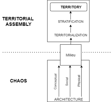
The most significant work of Deleuze and Guattari is “A Thousand Plateaus” (1980), is considered the most important work of French philosophy of the twentieth century and an exemplary text of postmodern philosophy. This work on connects philosophical materialism with the foundations of “neo-materialism Marx, Nietzsche and Freud with modern science “, and at the same time avoids the traditional determinants of materialism: determinism and vitalism[17]. This work makes it possible to leave the “paralyzing postmodernism, which captured important modern schools of geography and philosophy, and therefore contributes to the study of thought images (noology) and provides an unprecedented opportunity for the cooperation of philosophers and geographers through several key concepts that reconfigure the role philosophy”. This mostly refers to the terms: territorialization, deterritorialization, reterritorialization, landscape and miles. Spacious abstractions (lines, planes, aligned and grooved space) as well are of great importance and carefully identify mapping practices. This was implemented, primarily, due to the transformation of philosophical problems, and these theoretical innovations in geophilosophy have spurred new one’s achievements in geographical theory and practice:
Assessment of geophilosophical critical tradition and key concepts, refers to several main geographical elements, such as: the role of ‘small theory’[18]; the space and body being examined ‘Non-representative theory of influence’; ‘Ontological turn’ who re-examined the nature of space from the perspective of differences; new geographical approaches to the relationship between man and the environment, and which are inspired by ‘new materialism’, ‘vital’ materialism ‘and‘ zones of inconspicuousness ’between man and non-man (Woodward, 2017: 2866).
It is evident that the geophilosophy of Deleuze and Guattari implies a deep engaging in the field of dominant trends in the fields of philosophy and modern earth sciences. A thousand plateaus are full of geological and geographical terms, which A. Pair collected and edited Dictionary Deleuze’s notions[19]. In addition to the terms mentioned, Deleuze and Fortune Teller use and a whole range of concepts from other sciences (mathematics, physics, biology, ecology and anthropology) to create new philosophical one’s concepts. Critics of geophilosophy, from the philosophical (Protevi, Pair, Tampio) and the geographical aspect (Woodward, Bonta, Russell), emphasize the significance of the book A Thousand Plateaus. The form has been successfully developed in its new materialism, which politicized the “philosophy of differences”, ie. sense of geophilosophy, creates through the superposition of layers of thought. For this initial level of acquaintance with geophilosophy, he will mention are only the basic concept of territorialization, which represents “An expressive process of marking conceptual, social and physical architectures that provide space for cohabitation milieu with the surrounding environment “. On the contrary, deterritorialization refers to the dissolution or abandonment of existing territories as new rallies would be formed through a constant change of “opinion, movement, articulation, framing and other ways of coexistence”. There where deterritorialization is present, there are tendencies towards “Order, boundaries, codification, structure, stability, habits and restrictions”, while reterritorialization is used by the forces of chaos, clutter, variation, liberation, mobility and infinity”. Geophilosophy thus re-examines the nature of thought as “a geological process that is in constant contact with the earth itself” ss more of a movement of the multitude that “refers to territories, not to cognitive abilities limited to already formed objects”. Another important work by Deleuze and Guattari is What is Philosophy? (1995), in which they make certain correlations, e.g. “It’s a philosophy geophilosophy in exactly the same way as, from Braudel’s views, history geohistory”. Also, they deny that it is the reason for the historical privilege of Western philosophy and identify a philosophy with a supreme geographical concept, and that is for them contingency. Woodward (2017: 2867) through geography establishes a correlation between philosophy and geophilosophy in such a way that “the history of philosophy is important for a few geographers and that many attach importance to the wider implications of this geophilosophical reading”. That suggests yes philosophy and social theory are not products of pure abstractions, historical structures or “thinking in an armchair”. Instead, he quotes Deleuze and Gattari (1995: 96), who insist that “The theory arises from complex, set and unforeseen relations in socio spatial life. This frees thought and theory from Western excuses about need and truth. ” Because they suggest yes is geography more than “physical and human, but mental, like landscape, geography exhausts history from the cult of necessity to the inseparability of unforeseen circumstances was emphasized”. Because geography is placed in a central position in relation to creation theories and theorizing of work. By aligning geography with thought, “Geophilosophy presents the Earth as a plane on which concepts are conceived and materials arrange, create systems, solidify and create new arrangements or simply explode” (Ibidem: 2867). The complexity of understanding the geophilosophical aspect best reflects this quote as well:
To those who want to study The Thousand Plateaus, Buchanan recommends that they read Deleuze ‘s earlier works first (especially Difference and Repetition, Empiricism and Subjectivity, Nietzsche and Philosophy, Dialogues and Negotiations) to study classical texts psychoanalysis (including Freud, Lacan, Bettelheim, Klein and the Reich), master the literature on historical materialism (including the books of Foucault, Sartre, Fanon, and Turner) and investigate literary sources (including Artois, Lawrence, Proust, Beckett, Buhner, Nerval and Butler). Probably, once they realize this task, then I can begin to deal with the imposing secondary sources from geology, linguistics, politics, aesthetics and (thousands?) other topics highlighted in The Thousand plateau (Tampio, 2014: 3).
Deleuze and Guattari reiterate their belief in continued importance philosophy as a way of thinking and acting. They especially emphasize the existence of specific geo-traumas, caused by “robbery, sedimentation, unfoundedness and stratification of ecological conditions. Countries to maintain unregulated economic and social growth controls of geographical areas”, which ensure the future petrocapitalism. Interpreting these views, R. Negerestani (2008) in the theoretical fiction Cyclonopedia, oil and narcotics sees as lubricants of the post-industrial world of capitalism. Within it, as the first geo-trauma, he recognizes the need continuous conquest, commodification[20] and appropriation of ecological system by petrocapitalist regimes, while another trauma involves stifling creative forms of thought and the collective social action, which could prevent an environmental catastrophe by creating new ecologies, based on locality and activism. This form of geo-trauma effectively captures individuals and societies in a present that seems both unbearable and insurmountable, so “we continue to suffer shameful compromises” instead to explore creative alternatives for a future life path. Geophilosophy can be summed up in the idea that it is philosophy, or science in general, a creative milieu is needed for development in which “events can localize in time and space, but which are not explainable due natural characteristics of that specific environment”. For Günzel (2003), the identification of that creative milieu, in history science or the geography of ideas, is not one topic, but a central issue geophilosophy. Therefore, he recognizes two associations with the term geophilosophy (ecological and geopolitical), the first as “less or more esoteric” which has to do with ecological thinking in in the sense of “deep ecology”. The second can be considered philosophical the version of geopolitics used in the critique of implication political territoriality[21]. Roussel et al. (2017) emphasize adapting geographical notions of proximity, unpredictability, interdisciplinarity, including the linearity of historical idea, while Parrika (2015) notes that recently one a number of scientists have investigated “the convergence of speculative fiction with geophilosophy, as a way of solving social and ecological trauma” related to petrocapitalism, climate change and the biopolitics of the Anthropocene epoch[22].
Geophilosophy is seen as an attempt to explore the complex the meaning of man’s abode on Earth. As opposed to uniformity of the global world, which erases differences and peculiarities, by moving everywhere irreversible processes of eradication and loss of cultural identity, geophilosophy is, above all, focused on yes capture and protect the elusive spiritual, cultural, historical and the spatial physiognomy of communities and places, with an awareness of it that the meaning of our ‘earthly’ existence can be found only if one starts from the plurality of human communities that, each way in a unique way, they create time and place, giving them an absolutely unique and unrepeatable stamp. They reside in geohistorical and geo-symbolic spaces that never have closed in on themselves are already always open to arrival the other, the only one who can guarantee them not only survival, but life itself in the changing course of history, combining memory and change (Resta, 2017: 14-15).
We can now return to the ambiguity of the notion of geophilosophy. Simply put, geophilosophy refers to an attempt at understanding (philosophical aspect) of the conditions in which they arise and take place geographically (geological) processes. Another meaning refers to the deeply philosophical reflection (postmodernist interpretations). Based on the previous one’s examples, we have shown the complexity of such a geophilosophical concept and the difficulty of understanding it, which cannot be applied in geographical discourse. First, it is not the subject of study geography, and secondly, it requires a broader philosophical-psychological frame. So, we’re going to stick to the first meaning, because this term, outside the narrow framework (geography or philosophy), associates with the whole, that is, multiple aspects concerning the relationship between man and space. Thus, from a geographical point of view, the analysis of the theory is not the goal complexity on the example of different geophilosophical concepts. We believe that the goal should be to strive to discover the meaning of these terms (geographical aspect) and to make it so, by applying them (only basic geophilosophical concepts and in narrowly defined areas), would be a complement to the geographical methodology, and would enable us to do better understanding of complex geographical processes. Normally, ours understanding these basic concepts has a completely personal stamp.
It is imbued with personal imagination and deep thinking about oneself subject of geographical study, and thus deprived of existence universal meanings (on a personal level we can present it as: my path from me to you is not the same as your path from you to me). In order to achieve this, we will strive to adhere to practical recommendations Tampio (2014: 7-13), which suggests that in the study of Deleuze apply four rules. The first refers to the etymology, because and the notion of territory (one of the key concepts in the Thousand Plateaus) and its thought derivatives (deterritorialization and reterritorialization), they originate from the ambiguous term land. The second rule applies to image creation (allusion to Hegelian storytelling philosophy). This is because Deleuze also advises, in analysing concepts, that it is better to start with extremely simple, concrete situations, and not with philosophical predecessors or with problems as such. The third rule is that The Thousand Plateaus uses the method stratoanalysis (meaning a schematic representation of different layers), so they need to be presented and shaped in the form of diagrams. On the finally, the last rule refers to the need to create a theory. Deleuze describes it as mastering the “art of portraiture” because, according to him, it is not the goal of “creating the appearance of life” or repeating what said one philosopher, but “in creating similarities, by separating and the level of immanence he established, as well as the new concepts that created”. Accordingly, in our work we tried to apply all this, in addition to the offered dictionaries (philosophical and geophilosophical), we use certain allusions (e.g. a shopping mall in the early Minoan period), we apply diagrams in explaining the different process (territorialization and deterritorialization), and finally, as a kind of confirmation of such a methodological procedure, we offer the author concept (theory) of geophilosophy of territory (historical-geographical aspect) on which we live. Given the territoriality of geography spoken of by Kant (Elden, 2011: 147), it is obvious that it goes beyond purely geographical data and acquired symbolic, historical and philosophical dimensions. Because, the complexity of the geophilosophical approach should be supplemented by meaning geographical elements and their interpretability in the field culture, about which Gadamer wrote (Kremer, 2010), but also geopolitical significance of the population. This significance is best interpreted by two conflicting theories of global ethics. The first is the “ethics of the spaceship” which assumes that the Earth is a closed system with limited reserves, and the future of humanity depends on solidarity and rational use of resources. The second is the “lifeboat ethic”, which, as a neo-Malthusian theory, assumes that under limited resources can only survive rich nations that sail in “safe ship”, unlike poor peoples who are in insecurity and overcrowded ship”. Possible epilogues of this second ethic were explained by Grcic (2000: 260)[23]. Therefore, we will start this synthesis with Dan Brown, and finish it with Michel Uelbeck, the most intriguing contemporary authors who describing geographical imagination and some elements of science theory of population growth[24] through the challenges of the ethical and geopolitical narrative[25]. In their novels, disappointment is the general picture of society (an essential determinant of the postmodern), and the plots are determined by the questions: “Human” controls of demographic growth, experiments with the genome man, the challenges of artificial intelligence, by increasing the average aging of the population, the cultural transformation of the West through the weakening of the social significance of Catholicism / Protestantism in favour of atheism / agnosticism, as well as by increasing the number of members other religions, primarily Islam. Indications of these weaknesses of the West (colonialism and the cruelty of capitalism) and expected frustrations its inhabitants (unequal distribution of wealth[26] and loss of the individual), we recognized in the premodern, yet.
Photo 0.1: The wind tower or clock (horologium) is an octagonal tower, which was a combination of a sundial, an hourglass (water clock) and a weather vane, so it is considered the oldest meteorological station in the world. It is located in the Roman Agora (Athens), and above is the Acropolis, which shows part of the temple Erichtheon.
[1] This introduction was redesigned and presented under the title “Prolegomena for a Premodern Geophilosophy” at the 6th International Scientific Conference Geobalcanica, virtual event, Ohrid, 12-13. May 2020
[2] Real world abstraction, used in geography to simplify the vast the complexity of the earth’s surface and the search for analogies for geographical processes within others discipline.
[3] According to: Rediscovering geography (1997), there are three perspectives: geographical – looking at the world through a prism: places, spaces and proportions; geographical synthesis (ecological – social dynamics, environmental dynamics and human and social dynamics); spatial representation – uses: visual, verbal, mathematical, digital and cognitive approach.
[4] In a reference synthesis on geographical thought, Hubbard et. al., Thinking Geographically (2002), indicates ways of thinking within different philosophical traditions, and indicates that certain theories and their quality significantly depend on: ontology, epistemology, ideology and methodology. According to them, these four components define the parameters of studying each philosophical approach, even geography.
[5] See: Bonta, M. & J. Protevi (2004). Deleuze and Geophilosophy A Guide and Glossary, p. 191-192.
[6] It is considered a critical alternative in the field of social sciences and humanities in terms of understanding the world and questions of knowledge. Today, there are two lines of thinking about semantics of this notion, the first starts from the book by Berger and Lukman “Social construction of reality”, a the second is related to the notions of deconstruction (Derrida) and post / structuralism (Foucault).
[7] Agreement between Catholics and Protestants of Central Europe (1648), which defined the principles sovereignty and equality between states in order to establish lasting peace and friendship among States, with a mutually acceptable system of international law, based on international law binding contracts.
[8] According to the data of the UN “demographic clock”, which is located in Belgrade, to reach the number of one billion, humanity needed 1804, and then that time, necessary for increase in total population by a new billion, shortened years to: 126 (1930), 34 (1960), 14 (1974), 13 (1987), 12 (1999), 12 years (2011), and eight billion inhabitants can be expected 2023.
[9] Based on the UN Population Reference Bureau for 2019: https://www.prb.org/.
[10] D. Meadows et al., In a report by the Club of Rome, highlight the dilemmas they will soon face humanity. The sustainability of the planet’s development is linked to the harmonization of development and the understanding of interdependence between components within different complex problems. To that end, they create a model growth, based on five variables (population, agricultural production, raw materials, industrial production and pollution) and conclude that the biggest problem of sustainable development the planet represents the rapid growth of the world’s population.
[11] The journal is edited by A. Light (philosopher) and J. Smith (geographer).
[12] This is the name of Derek Gregory’s brilliant synthesis (1994), in which he creates a map of “intellectual landscape” through the connection of social geography with anthropology (cultural studies), sociology (social theory) and economics (political economy).
[13] R. Peet, Modern Geographical Thought, 1998.
[14] In philosophical terms, this is not a single position, and the best example is provided by the books of K. Jaspers, Buddha, Socrates, Confucius, Jesus (2019) and J. Habermas, Philosophical Discourse of Modernity (1988).
[15] According A. Petrovic: Wir Luft-Schiffahrer des Geistes.
[16] Sociological and philosophical term referring to an entity (man or any living being) which operates in a given environment. Agency theory is rooted in one of the oldest problem’s political philosophy, in understanding the relationship between the “master” to which it is given socially legitimate control over certain actions, and “servants” who control the information about which the “master” decides.
[17] Here Protevi meant the doctrine (Vitalism) according to which the functions of a living organism act
thanks to a life force different from physical and chemical principles, and whose biological activities determined by some supernatural force. Aristotle (entelechy) wrote about this, Kepler (formative power) and others.
[18] Category of Marxist and feminist practice. See: C. Katz, Towards minor theory.
[19] In Serbian version of this book (2020), translated terms are: assemblage, earth, genealogy, nomadism, organism, plateau, rhizome, smooth space, space, state, state + geography, stratification, territory, thought and transversality.
[20] See the geographical aspect of this process in: G. Mutabdzija (2016), Regional Geography of Europe.
[21] Allusion to Lyotard (1988), who papers of M. Heidegger characterized as a philosophy of “Blood and Soil”.
[22] The International Union of Geological Sciences (IUGS) states that the Holocene, which lasted, has ended the past 12,000 years and that the “epoch of man” (Anthropocene) has come. There is a dilemma about beginning of the Anthropocene, for some it was 1950. (nuclear tests), and for others the beginning of industrial revolution.
[23] The epilogue has three scenarios:
1. The boat saves everyone and then sinks or in translation: “complete justice, complete disaster”;
2. The boat of the rich selectively rescues the drowned (includes two alternatives):
a) Sooner or later, someone will “pay” for violating safety standards,
b) Criteria for the selection of drowned people should be defined (best, most needed or first).
This requires an explanation and what to say to the other drowned people who are outside the boat?
3. The boat of the rich does not save anyone, but defends itself from those who want to enter.
[24] Biological, economic and cultural.
[25] It is based on the matrix of endangerment of “domestic whites – Catholics” by “coloured people” immigrants – Muslims “which is recognized through a sharp demographic specialization (urban zoning) and the formation of a “no-go zone”. See: Mutabdzija, 2018.
[26] If we accept the explanation of Piketty (2015), it is manifested in the conditions when the rate return on capital exceeds the rate of growth of production and income, then capitalism leads to unjustified inequalities that undermine the meritocratic values on which they are based democratic societies. The first time this happened was in the 19th century, which can be considered economic the border of the premodern.
1. TERRITORIALIZATION: The idea of the world
Philosophy was a Greek thing, even though it was brought by migrants. To it arose, an encounter between the Greek environment and the plan was needed immanence of opinion (…) It was necessary to meet friends and opinions. In short, there is a reason – the cause of philosophy, but it is a synthetic and contingent reason – an encounter, a fusion. He himself it is not insufficient in itself, but it is contingent. Even in the notion, the reason rests on some connection of parts that could have been different, with different neighbourhoods. The principle of reason, as it appears in philosophy, is the principle of contingent reason, and is expressed in as follows: there is no valid reason other than contingent, no general history except contingency[1] (…) Philosophy is certain geophilosophy, just as it is, according to Braudel point of view, history a certain geohistory. Where does the philosophy come from right in Greece, right at that moment? The same reasons apply here Braudel states when answering a similar question about capitalism: whence capitalism in such a place and in those times, why not in China, at some other time, since many are his elements already existed there? (Deleuze and Guattari, 1995: 118-121).
It is believed that the term philosopher was first used by Heraclitus, a derivative of that term – philosophy, Plato began to use a century later. There is the consent of philosophers (Diels, 1983; Faye, 1990; Ramnoux, 1994) on the origin and spread of the philosophical opinions. Initially, this was a consequence of the colonization of the fringe’s Hellenic territories (late VII and early VI v. p. H.), which are provoked wars, but also trade between the Greeks and their eastern one’s neighbours, and then philosophical teaching developed in the far western as well parts (southern Italy and Sicily). That is why they are Deleuze and Guattari (1995: 111) described the birth of philosophy as a “happy accident” that is originated from various socio-geographical relations in antiquity the world of Greece. The victory of the Greeks over the Persians in the battle of Salamis (480 BC), repulsed the threat that Greece would be conquered. A new one has emerged a circumstance strongly marked by two processes, on the external plane it was the political autonomy of Greece, and internally, the cooperation between city-states within the Delian Alliance. In the new circumstance’s preconditions have been created for the transformation of the overall social, cultural and political life of ancient Greece. Exactly this situation they describe it as key to the emergence of philosophy, i.e., “Essential connectivity with milieu (milieu of immanence), which created a good environment for the emergence of philosophy. Still, Greek social, political and educational the environment was not sympathetic to philosophers, so they were Presocratic they acquired their education in Egypt and then transferred it to Greece. They are started two processes, the first as the deterritorialization of Greece (political autonomy and cooperation of city-states), and others refer to the ancient a philosophy that will foster new social and political ideals embodied in terms: essential connection, friendship, and opinion (immanence, friendship, opinion).
Territorialization
After these basic facts about the origin of philosophy, it is necessary is to clarify the essential spatial definition of geography. That is limited by geographical notions of territory and territoriality, and the geophilosophical notion of territorialization. The territory is most often used as a term that has a political (limiting power access to specific places or regions) or ethnic significance (in terms of the dominance that a particular group has over a space). In short, territory means the unique space it uses social group, individual or institution. It can have and radical meaning as “the end of geography”, which means that it has become the dominant geographical term (and imagination), which is in the social created by the sciences the awareness that there can be no territory without a state. The term derived from territory is territoriality, and which to Agnew (2009: 746) denotes as a property of territory, which can present as an international system of states or territories an expression of their sovereignty. Over this notion, modern the state has control over the population within the defined external borders. Territoriality is much more pervasive in others ‘Non-political’ contexts, and as a result of today’s increase theoretical pluralism and interdisciplinarity. It is common to are territory relations of limited space, and territoriality are referring to the activities of the state, related to the establishment and defence territory. That is why these are the most basic and most important concepts which represent the elements of socio-spatial organization, and which are have changed over time. The boundaries of the territory imply the practice of jurisdiction and determine the edge of sovereignty or regulation. They can mark the boundaries of legitimacy, membership, and participation voice. The territory is also important for determining the spatial scope application of the rules. It defines: what it is, where it is allowed, prohibited or mandatory. That is, the territory provides communicative boundaries by spatial fields of action and socio-spatial applicability of power. Sometimes territory is also used as a synonym for a place or space. It is present in the social sciences (sociology and political science), within which the territory is associated with network form of organization, because it makes it easier to understand complex the processes through which powerful organizations manage space (globalization and the internet). In defining the terms territory and territoriality, Delaney (2009: 196-208) emphasizes practical relations between concepts: space, power and meaning. Every of these terms refers to complex social phenomena, and in combined, increase the complexity of the concepts of territory and territoriality. Since we briefly defined the space in the introduction, here we will dwell on the remaining terms.
Power usually means the ability to act or ability imposing one’s will on others. It can be expressed and experienced in countless ways (political, economic, military, ideological, family …), and one very important characteristic of power is the degree institutionalization. It can be expressed through territoriality in various ways, and most obviously through the state and property (sovereignty and ownership). The source of this power is usually ideological derivable from the notion of sovereignty, which it has suffered over time significant changes. This is especially true of the original meaning (Peace of Westphalia), which in the meantime has radically transformed. Territory affects various aspects of power (authority, legitimacy, obligations, sanctions) in different ways, and new ones are often created territories in order to strengthen or consolidate different forms be able to. In practical terms (politically-geographically), the territory is can be used as a means of exercising neo – colonial power, and which can be achieved through divisions and conquests (regionalism), for “Dilution” of the opposition (politics), to prevent, exclude or denial of access to necessary supplies (sanctions), imposing impossible conditions (conditioning), to create a relationship “Vulnerabilities” (dependence), for confiscation (annexation), etc. This confirmed by numerous examples from around the world, which have been seen throughout periods of domination of retrograde social phenomena, such as were colonialism, slavery, racism, etc. Unfortunately, these social negativities did not disappear in the premodern period, but subsequently took only different forms (neo – colonialism, apartheid) and prove that circulation is directed across the territory power through social space, and to territorial policy (space and power), we often recognize in the elements of politics of meaning and interpretation. In this respect, the Balkan region is a field excellence for experimenting with these concepts.
Meaning is the third component that essentially determines the notions of territory and territoriality. It is much more complicated than the previous one’s concepts and has undergone profound changes through contemporary reflection on territoriality, which refers to social symbolic
opportunities (awareness, language and communication). Meaning is also realized through different forms, and the simplest and most obvious role of “meaning” (in related to territoriality), means territories as “meaningful” spaces or spatial “containers” of social significance that are they differ from each other, but also from other spaces. That is being realized across borders (define and distinguish), the lines they denote (landscape characteristics), and coded signs (conditions and rules, unacceptable and punishable). In addition to the notion of the meaning of territory, they are also related issues of legitimacy (authority) and interpretation aspect), and even more subtle forms, such as ideologies and discourses. Legitimacy and interpretation can be analyzed by example territorial configuration, which changed during different periods, thus changing the meanings and related power relations (e.g., segregation and spatial reconstructions). In the first case, meanings can be in the domain of racial and class (e.g., US cities in the nineteenth century), and the second case can be recognized as integrative (creation of nation-states in Europe in the second half of the XIX c.) and the disintegrative process (disintegration of the Roman Empire during V c.). By ideology is meant more or less elaborate, internally coherent, common set of beliefs, dispositions and a picture of power or simplified, it is a system of ideas that he studies or represented by an individual or group. Ideologies are presented through discourses, which represent written and oral communication and can be considered conventional or institutionalized ways thinking. Since the territory is primarily considered spatial phenomenon, because space (geography) is in social thought compatible with time (history), the territory can be easily understood as a relatively atemporal or static category. Yet, territory should be viewed as a process, within which its power transmits to the unfolding of events in time. Just like our weather the framework allowed us to understand a multitude of interpenetrating one’s space (in the introduction), so time can also be broken down into temporal frames, of different interrelated durations, from the current one to the deeply historical. This approach allows “creating and reshaping “the meaning of the territory, but also new concepts that they emphasize temporality, as an irreconcilable dimension in action territory and territoriality. Such notions are territorialization, deterritorialization and reterritorialization.
Crown stone[2]
From the notion of territory, Deleuze and Guattari derive a crucial notion geophilosophy – territorialization. In clarification and interpretation geophilosophical concepts, Bonta and Protevi (2004: 158) state that for Deleuze and Gattari territories do not have a fixed definition (separated by a border from an external threat), but it is only a passing place, conceived as assembling which is in a constant process of transitioning into something else, while maintaining internal organization. Territory refers to a movable and variable center (vector) that can be determined as a special point in space and time. It does not possess specific connections (nostalgic or xenophobic), but expresses experiential concept (neither symbolic nor representative and has no meaning).
As a set, territory expresses a series of ever-changing one’s heterogeneous elements and circumstances which, for various reasons, gather at a certain time. Primarily, the territory is marked the way the movement takes place through it, not the state borders. It does not hinder the process of deterritorialization, nor does it provide the opposite or dichotomous expression, from which it can occur deterritorialization. Instead, it is a constant accompaniment through the act escape (line of flight) in deterritorialization processes. Relationship between the territory and the country shows that the territory does not leave own principle of organization, but, unlike a particular or localized time and place (offered by the territory), the country offers alternatively complex assembly over different productive line of becoming or establishing. However, it is still not clear to us, to the end, what is territorialization!
Diagram 1.1: Territorialization process
I remember my astonishment and misunderstanding of art compositions The Last Judgment in the Vatican Sistine Chapel. All I needed was a “crown stone” to understand that fresco, and I found it in the first sentence of the guide: “right chosen, left convicted”. Everything opened before me, including the Creed (… and who sits at the right hand of the Father) and Book of Holy poems in which 318 Holy fathers are mentioned of the God – bearing fathers (number of Saints fathers on the First Ecumenical the Council of Nicaea, but also the number characters on the fresco). After being simplified like this introduction, let’s try this one geophilosophical concept we observe through a prism urban geography, for example of ancient Greece. Crete is over prehistory became several times territory, because each the path changed “the way of moving over him”. That means she is striated and smoothed territory (striation and smothness), whereby it is built into its specific structure, in the broadest sense of culture of life, which had its meaning (agrarian, commercial, political …). For the first time, in the early Minoan period, Crete ceased to be a territory. The advanced potam cultures of that time (Mesopotamia and Egypt), had are lively trade contacts and because of the great mutual distance (probably for practical reasons), they decided to build in Crete “shopping mall and gas station with accompanying facilities”. They constructed Knossos, the first European city, on the matrix of elaborated urban solutions from the mentioned advanced cultures. There was no one on the other side of the island a neighbouring town, and in who’s archaeological remains clay has been found tile (disc from Festos), which testifies to the existence of the first syllable linear writing and the birth of the Minoan culture, which is associated with the king Minoa. He was supervising the construction of the labyrinth one day, when he heard a muffled rumble and a terrible bang …
I’m going to Crete. In short period I have visited Knossos, Festos, Agia Triada, Archaeological Museum. Too much information. I flee from the ugliest Greek city (Iraclion) and went to the west. I come by boat to Balos, the most beautiful beach on the island, where on the sand I draw the lines of cultural transformation of this territory. At the moment I see a bigger wave, it will surely erase all the “furrows” soon which I built into the “territory”. I understand, “alignment” follows, a then … A new process begins.
The idea of the world
The study of the world of philosophy and geography should begin with Mediterranean, because even Plato vividly described it “as a ‘navel’ or the origin of humanity around which we have settled like frogs around the pond” (Durant, 1996: 13). Because they run from its shores the origin of the most important civilization, and given the importance scientific and cultural stimuli that radiated from here according to the rest of the ecumenism, we can imagine this basin as a Miller – Urey primordial soup[3] in which a futuristic Dan Brown’s[4] narrative about the origin of science. Viewed more broadly, The Mediterranean is also the cradle of European philosophy, culture and science essentially determined by the Jewish – Christian tradition. From a geographical angle observation, this significance of the Mediterranean is the result of good geographical position between the then most advanced civilizations from Egypt and Mesopotamia, favourable natural living conditions and greater population concentrations relative to neighbouring regions. Based of these assumptions, philosophy and science begin their historical development at the beginning of the VI BC on the east coast of the Mediterranean.
The main stages of these most significant changes in human history societies, were found in numerous Greek polises in Asia Minor (Miletus, Ephesus, Halicarnassus, Pergamon) and Egypt (Alexandria). With by the colonization of southern Italy, the centres of Greek philosophy and science moved west, to Elijah and Sicily, and peak during antiquity period of development is achieved by Athens. And really, the Mediterranean was the world stage, and Athens hers the center, where for two millennia, in Greek and Latin, played the most important plays in various scientific fields. Geographical performances were part of a broader, philosophical composition, within which there has always been a dichotomy of scientific ideas and principles, and which significantly determined the character of geographical thinking. Good basis for understanding ancient philosophy, but above all geographical knowledge and the principles that guided these philosophers and geographers, provide numerous books on the history of philosophy and historical geography, through which they will dive into the wondrous world of ideas of antiquity and try to recognize those who will create the imaginative world geography. To that end, in addition to the necessary epistemological indications and clarifications of basic philosophical concepts, research focus will refer to the period of the ancient age, during which they developed different schools and methods of (geographical) cognition and basic geographical ideas about the origin of the world, from the aspect of the religious and the mystical (cosmogony), its structure, but also more philosophical and scientific interpretation (cosmology), and practical geographical knowledge (mainly navigation).
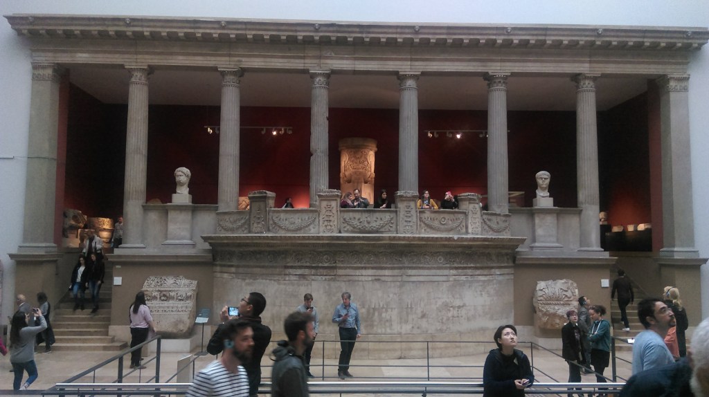
This narrowing of the subject of research seems more appropriate for the geographical aspect of the analysis of ancient philosophy, and will enable and more concise monitoring of the development of geographical ideas. Because even then they are there were questions about the origin and purpose of the cosmos, about the natural laws, population distribution, construction and functioning cities, as well as a number of other geographical aspects they are about numerous philosophers have given concise answers. In the Greek cosmogony of Gea is a basic element that emerges immediately after Chaos and represents the feminine principle of creation. Gea gave birth to Uranus (Heaven) by herself, high mountains (Orea) and the sea (Pont). The first written indications cosmogony representations are found in Hesiod[5] in the epic Theogony (Genesis of the Gods), which, along with Homer’s Odyssey and Iliad, makes the oldest source of Greek mythology. Theogony is the first Greek a mythological synthesis that discusses the origin of the world and genealogy of the gods, in which an attempt is made to affirm Zeus as the highest and greatest deity. The cosmogonic narrative starts from the cosmic egg, which give birth to the cosmic Night (a symbol of darkness and moisture hidden in the earth, thus embody erotic, fertilizing power) and Wind (symbol of light airspace). From that egg, a bisexual Eros is born who’s the female nature manifests as the Moon, and the male as the Sun, which by its it fertilizes the earth with heat. In the description of Erot, M. Djuric[6] states:
Eros is the god of love, who is in Hellenic literature first occurs in Hesiod. Homer does not know Eros yet: Erot as a son Aphrodite and Ares are among the younger members of the Olympics of the divine house. On the other hand, he is an old Hellenic god of nature, and as such has a considerable role in the cosmogonies, where he becomes after Chaos and Gaia from the dark, elemental powers, the first a beauty among the gods, who conquers the hearts of all the inhabitant’s heaven and earth, the principle of all development, and at the same time (besides Chimerosa) an inseparable companion of Aphrodite. Before Hesiod, it occurs in the Orphic teachings about the world egg from which it is derived with light emerged as a creative force in development nature and is called by various names like Fanet, Metida, Ericapeus: this is cosmogonic Eros (Plato, 2015: 130).
Hesiod made a significant contribution to the understanding of history periodization[7], which as subsequently modified. Mysticism also belongs to this religious mystical cosmogony narrative the belief of the god Bacchus or Dionysius. Russell (1998: 34-39) states that anyone who wants to study the development of Greek thought must understand the cult god Bacchus. Out of reverence for this god came true mysticism, which greatly influenced many philosophers and even had a share and in shaping Christian theology. Close to the belief in Bacchus is the Orphic[8] cult, whose worshipers are called Orphic.
They were an ascetic sect; wine was just a symbol for them, as later in the communion of Christians. Intoxication to which they are the aspiration was `enthusiasm`, unity with god. They believed to acquire in this way a mystical knowledge which cannot be acquired by ordinary means. This mystical element entered Greece philosophy with Pythagoras, who was a reformer of Orphism, as Orpheus was a reformer of the religion of Dionysus. Across Pythagoras, the Orphic elements entered Plato’s philosophy, and through Plato to most of the later philosophy which is to some extent was religious (Russell, 1998: 38).
Similar to Homer’s ancient cult of the holy number three, and for this one analysis can be an appropriate choice of the three most important philosophers (Anaximander, Plato and Strabo), who during the three different periods of ancient Greece (pre – Socratic, anthropological and post – Aristotelian) offered the rational answers they led rejection of religious – mystical explanations of natural phenomena and process and the establishment of geographical scientific thought.
[1] Accidentally or something that may or may not happen. For example. Deleuze and Guattari note that it is meaningless that Hegel and Heidegger sought some necessary and analytical reason to connect the emergence of philosophy with Greece.
[2] Finishing stone in a circular roof structure, e.g., Atreus’ tomb (Of Agamemnon’s father) in Mycenae.
[3] This experiment referred to an attempt to prove a theory of the origin of organic matter from inanimate nature, and in our case represents a kind of beginning or the beginning of the creation of science.
[4] Dan Brown, Origin, 2018
[5] One of the first ancient thinkers, a contemporary or somewhat younger than Homer.
[6] Plato, The Feast or On Love, talk, remarks and explanations.
[7] Golden Age, Silver Age, Bronze Age, Iron Age, Hero Age.
[8] According to Orpheus, a mythical beautiful hero who played and sang wonderfully and for his love (Eurydice) descended into Hades (the underworld) and tried to deliver her. This cult was transferred from Egypt to Crete.
2. DETERITORIALIZATION: THE IDEA OF GOD OR GEOGRAPHY THE MIDDLE AGES
Deterritorialization
The constant movement of the earth[1] causes deterritorialization on a place that transcends any territory, making it what it is “What deterritorializes and what is deterritorialized.” That’s why Deleuze and Gattari (1995: 107) emphasize that the earth merges with movement those who leave their territory, and they recognize it, e.g., like moving animal species in search of food, an army that performances or pilgrims who “ride the path of heavenly salvation.” The earth encompasses all elements, but serves only the individual (one or two) to deterritorializes the territory. These movements deterritorializations cannot be separated from the territories “that are open to another place, and the processes of reterritorialization they cannot be separated from a country that gives territories over and over again”. According to them, they are two components (territory and country) with two inseparable process: deterritorialization (from territory to country) and reterritorialization (from country to territory).
They they express the dilemma of what comes first: “Greece is the territory of philosophers or the land of philosophy?”. We can simplify this by asking what is older (chicken or egg), so expand their dilemma: is its Greek country of philosophers or territory of philosophy? In both cases we have clear answers: if philosophy has deterritorialized Greece was then reterritorialized by philosophers. The reverse is also true, if philosophers have deterritorialized Greece, then it is philosophy reterritorialized. Another example of deterritorialization is seen by Deleuze and Guattari in pure geographical notions of state and city. State by means of the imperial space (spatium) performs deterritorialization of the original territory in a way that “appropriates the territories of local groups” and agricultural territories “puts one against the other and compares them by making them subdivides under one higher arithmetic unit”.

This confirms the wound political-geographical thesis on the organic growth of the state (Ratzel), which it is expressed through the imperial power of the state, which strives to conquer new one’s territory (to the level of rounding off natural boundaries), which then unifies in the domain of agricultural production (from the Roman agers to feudal plantations). At the same time, the city using trade flows adjusts the urban expansion, and thus adjusts its own territory of “extensible geometric space”. Development of capitalist social relations a historical one is established the connection between global processes of industrialization and urbanization, and which are mirrored locally through the interaction of the city and environments. This can be presented interdisciplinary, on a level economic research (industrialization, deindustrialization and reindustrialization) and spatial planning (urbanization, deurbanization and reurbanization), which is explained by numerous examples, from location theories and concepts of polarized development to the model of economic development and the doctrine of regional planning.
Geographically, the consequences of this interaction of Soja (2013: 279) recognizes that “increased sectoral market segmentation labor intensifies geographical fragmentation and segregation of the workforce”. This means a change in the economic structure in the highly developed urban areas leads to greater employee participation in creative and innovative industries (high technology and financial sector) in relation to traditional industry. At the same time, the emergence of labor segregation (class, racial, ethnic), visible is at the residential level (residential zone) and in the workplace (according to the complexity of work tasks). These examples in the domain urban geography, is best explained by a change in territoriality in capitalist frameworks (production and reproduction), and which can also be expressed as follows: “Separate and divide in order to unite, dismember to intersect, dismember to embraced, segmented to totalize, set up fences to homogenized, individualized to eliminate alternatives and differences” (Poulantzas, 1978: 107).
Guattari (2018: 12) through complex psychoanalytic concepts and mathematical relations creates schizoanalytic cartography geophilosophy in which it clarifies the roles of deterritorialization in creating two zones of historical fractures, and on the basis of which they are the two most important processes took place: the age of European Christianity and the age of capitalism deterritorialization knowledge and technique. First the age is marked by “the new by understanding the relationship between Earth and Power “, which is formed on the ruin’s empire (Roman and Carolingian), and which he identifies with the figure subjectivity and shows it as double “Articulation”. First refers to “relatively autonomous basic territorial entities ethnic, national and religious character “, which are in the beginning formed as parts texture (feudal segmentation) which is held to this day. Other articulation is tied to the Catholic Church as “deterritorialized entity of subjective power”, which is structured as a collective tool at European level. In the challenges that followed during high school century (barbarian invasions, epidemics, incessant wars), European Christianity found an “excess of consistency” in the creation of the six a series of factors[2] that enabled him to survive.
Deterritorialization has its own rules, which Deleuze and Guattari (2013: 196) are shaped into theorems, and given its character, they distinguish: negative, positive, absolute and relative deterritorialization. The first theorem emphasizes that nothing is deterritorializes itself, but that “there are always at least two terms: hand – a useful object, mouth (babies) – breasts (mothers)”. Each of these terms are subsequently reterritorialized to another, where there is no return to the original state (ancient territoriality). This implies that the reterritorialized element serves as new territoriality to some other element that has lost its own territoriality, thus beginning the whole system of horizontal and complementary reterritorializations. Let’s explain it like this, it is true that the hand is used for grasping, but it is also an example of relative deterritorialization (during evolution, the front paw of a hominid transformed into a fist). Its complement (correlate) represents utility object or tool (e.g., the club is deterritorialized branch). In the continuation of the process, an example of the reterritorialization of the hand can be a prosthesis (replacement for a lost arm) or a locomotor fist (robotic arm). Another example is illustrative (lips – chest), which indicates that only men have lips, that is, that women have breasts.
Deterritorialization of the mouth (muzzle?) Created the lips by twisting mucosa outward), and by deterritorialization of the mammary glands in female hominids, breasts formed. So, lips and chest serve as a correlate to each other. Another theorem relates to velocity and intensity of deterritorialization and clarifies that the fastest element combines its intensity with the intensity of the slowest. This leads to the third theorem, which indicates that the less deterritorialized element, reterritorializes on a more deterritorialized element, whereby another system of reterritorialization (vertical – from bottom to top). This leads to similarities between reterritorialized organic elements, “e.g., arm and chest are face “, but also useful objects,” e.g., house, supplies or a garment, which can be said to be looking at me”. Let’s try now present it with examples as well.
In the introduction to the first part, we clarified the terms: territorialization and furrowing or striation. We realized that by drawing line in the sand, we bring a certain structure and meaning into it (we furrow the territory). You guessed it; the term furrowing fits the process of deterritorialization. During the Middle Ages, the elements deterritorialization can be recognized by numerous examples. This was a period in which grandiose changes took place, from political maps of the world (“eternal” Rome was inherited by the magnificent Byzantium), the most popular monotheistic religion emerged (Christianity), a new world was discovered and North America in it. This territory (e.g., the prairies of the Midwest) was inhabited indigenous population (Indians), which is in that territory built in a specific structure: dwellings made of light materials, growing only local crops, and hunting and fishing were basic economic activities. All this gave a deep sense of harmony in which man lived with nature, in the absence of violence. Arriving of Anglo-Saxon settlers, everything changed. In the new structure territories, Indian dwellings were replaced with immigrant farms and their cities, a completely new infrastructure has been built. The meaning of the territory also changed, it disappeared peaceful and idyllic a picture of the prairie, and a living agrarian space full of convulsive struggle was created for material goods. Everything was accompanied by a very high rate of violence and terror. It is now clear that deterritorialization has been carried out, which is annulled the previous structure and meaning of the territory, which became country. The process goes on. One day oil was discovered in the prairie …
[1] The translators of Deleuze and Gattari (1995, 2013) write the term earth differently (small and capital letters), which leaves a dilemma as to which term is meant.
[2] Promotion of monotheism, establishment of parish schools as a cultural lattice, establishment “Data banks” (occupational corpora, guilds, monasteries, religious orders), the use of iron and mills (crafts and citizenship), the emergence of the first machines and the selection of plant and animal species.
“Nothing contributes to the development of a healthy human mind as much as geography”
Immanuel Kant (Lectures in Physical Geography)
3. RETERITORIALIZATION: THE IDEA OF MAN OR CIVIL TWILIGHT[1] BETWEEN PREMODERN AND MODERN
Geophilosophy is seen as an attempt to explore the complex the meaning of man’s abode on Earth. s opposed to uniformity of the global world, which erases differences and peculiarities, by moving everywhere irreversible processes of eradication and loss of cultural identity, geophilosophy is, above all, focused on yes capture and protect the elusive spiritual, cultural, historical and spatial physiognomy of communities and places, with the awareness that the meaning of our “earthly” existence can only be found if we start from the plurality of human communities that, every time on unique way, they arise time and place, giving im absolutely unique and a unique seal. Oh no reside in geo-historical and geo-symbolic spaces that have never been they are already closed in on themselves always open upon arrival the other, the only one who it can guarantee them not only mere survival, already life itself in change throughout history, merging memory and change (Resta, 2017: 14-15).
Reterritorialization
Clarification of the process of reterritorialization should begin with the term Earth (land / land, terre), described by Deleuze and Guattari (1995; 2013). They make an essential difference between the earth (earth. Eng. ground, Fra. salt) and territories (Eng. territory, Fra. territoire), terms which express ways of occupying earthly space by different social machines. So is the term new country (Eng. a new earth, Fra. une nouvelle terre), implies new human relationships, starting from the creative potentials of material systems, which they can form specific forms from different means. She represents the art of using intensive material, ie. the reciprocity of absolute deterritorialization and the presence of cosmic force. Land (Eng. land, Fra. terre) consists of excess coding of territories under the signifying regime and state apparatus and refers exclusively to furrowed (cultivated) space and represents a terrain that can be owned, held as value, distribute, rent, prepare for agrarian production and tax. Land can be networked, distribute, classify and categorize without physical experiences. Gattari (2018: 15) clarifies the role of deterritorialization in creating the zone of historical rupture, on the basis of which it was created the age of capitalist deterritorialization of knowledge and techniques. This one capitalist subjectivity[2] will be confirmed only from the 18th century. and will be marked by a greater imbalance of the human-machine relationship. Man will lose social territorialities, and “reference the universe of a new generalized ideology of exchange „will no longer exist segmental territoriality is already capital as a “modus semiotic reterritorialization of human activities and structures”. We can now return to the examples we have given in the previous one’s chapters. Speaking of territorialization in the early Minoan period of Greece, we have said that the inhabitants of Crete during times created a territory. With the arrival of members of the advanced civilizations from Mesopotamia and Egypt, were imported elements of the urban structure on their island. That was an example deterritorialization (from territory to country), which is furrowed. Sudden volcanic eruption on the neighbouring island of Santorini she changed everything. She produced tsunami, but also physically destroyed much of the island (about that today witnessed submerged caldera). The Minoan civilization was also destroyed in Crete. The surviving remnants of that culture begin a new life on the nearest mainland (Mycenae, Argos, and Tire in the Peloponnese), and that junction new and the ancient culture was called the Cretan-Mycenaean civilization. It is clear, the eruption of the volcano Santorini reterritorialized Crete (crossing from country to territory), but at the same time deterritorialized Peloponnese (furrowing of completely new cultural contents).
The second the example concerned Anglo-Saxon settlers in the North America. Expulsion of the indigenous population and destruction their material cultures and then the construction of new elements material cultures of immigrants (furrowing), represented the process of deterritorialization (transformation of territory into land). We said that, in addition to the structure, the meaning of the territory has also changed (hunting-gathering society passes into agrarian-cattle-breeding). I’ll find out oil, the structure changes again (instead of farms, oil is created fields) and meaning (livestock regions grow into industrial fields). So, oil has reterritorialized the American prairie (from country to territory). Finally, the mentioned example of social subjectivity, in the European context, we can observe through processes of territorialization of empires (Roman and Carolingian), which are then deterritorialized through feudal fragmentation (religious and political) and then reterritorialized through capital.
The idea of a man
To explain the strange status of geography in the long millennium period, should start from Glacken (1967)[3], the author of one of the first comprehensive studies on geographical thinking during the premodern. He states that the medieval interest of philosophers in geography derives from “the tension between man and God, human finitude and divine innumerability”. From this point, for medieval philosophers, knowledge of the Earth as God’s creation is geographical knowledge, which should approach the work of God. However, this one line of thinking implies abandoning geography as codified knowledge, ie. a kind of betrayal of the efforts that are in antiquity times whether geographers, e.g., Eratosthenes, Strabo and Ptolemy.
On the in a way, it was considered a devaluation of geography as a science, because it implied the idea that knowledge of the Earth could be complete transfer to philosophy and theology. These philosophical-geographical changes can be observed through a paradigmatic interpretation of position Earths in space, ie. duration of geocentric system theory. It is also necessary clarify the reasons for the great stagnation in geography, and whose we have roots in the previous one’s chapters described in the teachings of Aristotle and Ptolemy, because it is their influence to medieval thought, as and attitude toward theology, bio very powerful. We saw that they were cosmogonic and cosmological notions of the cosmos and the Earth seemed paradigmatic scientific performance, which it was dominant since antiquity period until occurrence the Copernican revolution, some elements of Aristotelianism they were refuted only in the 17th century. It was, above all, based on the power of authority (the church), not on the basis of experience (experiment). Aristotle’s vision of the world was based on the fact that it is “translunary or supralunar” (the one farther from the Moon) celestial a space perfect and in which there are no changes. Also, see we are that Aristotle in “Meteorology” claimed that because of the unfavourable climatic factors there are vast uninhabited areas in between two returnees (tropical zone) and in the cold areas of the north and south, and Ptolemy advocated a geocentric system. The geographical opinion that developed during the new century did not emerge[4] suddenly and out of nowhere. The period between 9th and 13th c. marked development education, but also restraining critical thinking. In the monastery schools developed scholasticism – the teaching of church dogmas, and in large urban centers created the first universities (Bologna, Coimbra, Paris, Oxford).
This is also the period when the Catholic Church is on established an inquisition in the area of Western Europe – an obscure system judicial institution, which lasted from the 12th century until the end of the 18th century with the aim of fighting heresy[5]. The methods of action were different prohibitions, from the use of “suspicious” literature to free distribution scientific views that violated certain church truths and notions of the world, and the consequences of this ecclesiastical radicalism where are the burning of books, and the persecution and murder of suspects. After a series of great geographical discoveries from the 15th century. there will be a period the rise of science, and thus of geographical thinking. This period of three and for centuries (from the discovery of America to the deaths of Humboldt and Ritter) was is filled with a series of major scientific and overall social upswings, a which created the preconditions for the completion of the premodern and the beginning scientific geography or the modern period. They marked that period major socio-historical changes that began with a weakening the influence of the church, the strengthening of royal power (absolutism), growth trade and the creation of a bourgeois social stratum. These changes are affected most European societies, and we recognize them as a breakdown feudalism and the emergence of early capitalism, a period of religious exclusivity and the wars between Catholics and Protestants, the beginning of the colonial one’s conquests, the rise of the human spirit and reason during humanism, the Renaissance and of the Enlightenment, but also the rise of science.
[1] Geographical expression for the position of the Sun just before dawn (sunrise) or night (sunset). It is the astronomical position of the Sun between 00 and 60 below the horizon, when it had not yet reached full day or complete darkness
[2] The main factors of this consistency are: the appearance of the press, the primacy of steel and steam machine, time manipulation (chronometer machines) and biological revolution (starting from Pasteur) created urban content (trade).
[3] Think of his book: Traces on the Rhodian Shore Nature and Culture in Western Thought from Ancient Times to the End of the Eighteenth Century (Coast of Rhodes – traces of nature and culture in Western thought from ancient times to the end of the eighteenth century).
[4] In terms of philosophical periodization, it refers to the period between K. Columbus (1492), death. В. Hegel (1831), and in geographical terms, it is a somewhat shorter period that ends with the work J. Watt (1769) and the beginning of the Industrial Revolution.
[5] Indicates all opinions about religious dogmas that differ from the official teaching of the church. In a broader sense, heresy is a teaching in philosophy, politics, or science that differs from that which is generally accepted as an authority.
4. GEOPHILOSOPHY OF PREMODERN OF CENTRAL BALKANS OR FROM ZVECAN TO ZVECAN[1]
In the introduction we stated that we will geophilosophy, as spatial concept, applied as a supplement to the geographical method, and s with the aim of better understanding historical-geographical conditioning, political-geographical evolution and dialectics of regional-geographical forms[2]. To look at the observed geographical area comprehensively and consistently, it is necessary to establish clear methodological one’s determinants. They refer to the definition of the spatial framework and time duration, and the application of specific historical-geographical and political-geographical methodologies in selection, processing and comparison reference space-time units. The term central The Balkans is not a very characteristic geographical term and does not exist precise geographical boundaries. This is a more metaphorical term relating to the territory of Bosnia and Herzegovina (throughout history, BiH had a different geographical definition) and neighbouring countries (more precisely, border areas towards BiH). In a broader sense, we can geographically define this space as an irregular square whose edges are: the Adriatic coast in the south-southwest, the Drava in the north, line Zadar-Virovitica in the west, and the Danube, Morava and Drim on east-southeast. This approach relativizes the existing one state-legal system, because their shape, size and name, during of the historical period is not, and cannot be, a permanent category. This term, primarily, it indicates strong interaction and essential conditioning between different political-geographical units (as political entities, throughout history have had a different geographical definition), which existed in this space and has no other meaning.
We mentioned that the premodern period, according to Peet (1998), is defined as a period between the emergence of philosophical thought (ancient Greece) and the years of Hegel’s death (1831). It is clear that this chronological range, absolutely, it does not correspond to the scientific situation in BiH. This space enters the world of history (appearance of letters and written documents) only with the arrival of the Roman Empire in the Balkans (Latin and letter), and the level of scientific thought reached in the Ottoman Empire it did not possess elements of modernity (relation to Hegel ‘s work, the absence of a unified philosophical system, the emergence of more philosophical directions, and turning to the problems of man and his existential issues). It is clear that in the feudal theocratic society, such as the Ottoman Empire, were not present ideas like this. Also, it is important to mention that during this long period, in a way, spread certain philosophical ideas from neighbouring educational hotspots. Such places were political-geographical centres (entities), which we could define in terms of space as: medieval Serbia (from the 11th century to the 15th century), The Republic of Dubrovnik (15th-18th centuries) and the Austro-Hungarian Monarchy (18th – 19th centuries). The earliest philosophical source, through which the elements are Greek ancient logics penetrated Byzantine ecclesiastical philosophy, and indirectly in the Serbian Orthodox Church and in this area, they connect are for the monk Theodore[3]. In the domain of natural philosophy, the greatest Ruger Boskovic contributed to the world philosophy of his time, for which B. Petronijević[4] said that he was “the greatest citizen of Dubrovnik and the most famous Serb to this day … and that he is next to Copernicus, Lobachevsky and Mendeleev, one of the few Slavs before high science”. On the in the end, Dositej Obradovic was the first scientist to come up with ideas Enlightenment in our area (he was also the first Minister of Education Serbia). From this it is clear why the border is too modern, when it comes to BiH, should be moved to the end of the 19th century. (Berlin Congress). In domain selection, processing and comparison of reference space-time unit, we will dwell on the conventional division of history into early (5th – 10th century), developed (11th – 13th century) and late Middle Ages (14th – 15th century), and the new age (from Columbus to the First World War), and in the spatial differentiation we will give preference to the historical provinces (homogeneous regions) in relation to state entities.
4.1 CREATION OF TERRITORY
The Iron Age represented the final stage in a long cultural march through prehistory. Its end in the central Balkans signifies two grand events: the birth of Jesus Christ, but also the beginning historical process. The first event will make full sense in the Balkans get only after one millennium (baptism of Slavs), and others is associated with the victory of the Roman Empire in the Illyrian wars. In order to understand the framework in which the territorialization of the Balkans took place, a cursory review of the basic characteristics of the cultural is necessary development during prehistory. Three important determinants stand out. First refers to understanding the development of primitive cultures and then and civilization and cities, during which it played a crucial role the constant interaction of different cultural groups within the wider of the Mediterranean circle, from which some new cultural arose reality (mostly more advanced than the previous one, although they are numerous and examples of destruction of existing ones). And really, during prehistory cultural influences were transmitted from the Middle East and Asia Minor to Europe, mainly across the Aegean and the Balkans, being from those contacts formed various forms of material culture, and the Balkans took on Eurasian cultural outlines. If we were this archaeological reality wanted to plastically express the language of geography, then we would use the theory of geographical “merging properties and permeation” and their opposite “isolation and separation properties by J. Cvijić, which was applied to the Balkan Peninsula and makes the basic idea of connection in anthropogeography. It is designed in the “model of points of attraction (in recent terminology of growth centres) and the properties of merging and permeation (in modern terminology axis of development), and in the new age will take the form of a center model – periphery” (Grcic, 2008: 4-5).
Another determinant is the material trace of these cultures (artifacts), which is preserved in the soil, and as a result of the difference in the rate of formation of the pedological substrate and destruction of cultural remains. The process of soil formation (pedogenesis), is the result of the influence of active (climate and organisms) and passive factors (relief, parent substrate and time), which are enabled the “conservation” of the material remains of earlier cultures in the cultural layer. The thickness of this layer is proportional to the total duration of the cultural period (total period of a person ‘s stay at that locality), and the duration of individual cultures (Palaeolithic, Mesolithic, Neolithic …) at a given locality corresponds to the thickness of a given horizon.
The cultural layer in Vinca is 10.5 m thick, with the Neolithic horizons, of the Eneolithic and the medieval period lie successively one above another. From archaeological material from these cultural strata “Read” is the history of cultural development at a given locality. The third determinant is a multi-layered transformation of prehistoric man, which we recognize, first, as professional. It refers to a change in his basic occupation as a collector fruits – a hunter and the role of a fisherman, then a farmer, cattle breeder and craftsman. The social dimension of this transformation is visible through change habitats, which are moved from the original cave and sub cave to dugouts, soybeans and simple huts, and then into solid buildings of stone, and at the end of this chain are the palaces of the aristocracy and, finally, cities. The cultural upgrade is visible from the original drawings on the walls of caves, making stone figurines and jewellery from bones, various weapons and tools, decorated pottery and objects of metal. The culmination of this cultural development is the emergence of writing, which represents a sharp boundary towards the beginning of the historical age. This it did not happen at the same time in Europe, not even in the Balkans. It’s in the Aegean the appearance of the first “linear B” letter related to the Mycenaean civilization (2nd millennium), and the origin of the Greek alphabet falls in the 9th century BC, by which history officially begins. The Balkans had to wait for this opportunity the arrival of the Romans in the first century, which was also an introduction to later Christianization. Understandably, they did not exist in the Balkans in the prehistoric period clearly differentiated geographical regions, it is already possible from this distance speak only of areas inhabited by certain ethnicities communities (Illyrian tribes).
Territorialization
According to the previous description of the process of territorialization (see diagram 1.1) we understand that prehistory represented Chaotic miles from which matter and energy (in our case) population substrate) spilled into the territorial complex at the beginning historical period. This is where the territorialization of the social began stratum (tribal differentiation) and its stratification (building a specific tribal material culture). More on that we learn through the archaeological remains of these cultural groups, which were researched by Benac (1979: 737) and others. Archaeological site of iron ore mines in the vicinity of Prijedor, say they are Iapods were skilled in mining and metallurgy. Also, based on research numerous tumuli (necropolises) in Romania have been discovered archaeologically the remnants of the Glasinac Group, which showed that among the Authorities, in addition to cattle breeders, there were also good metalworkers. This is was the most prominent group of the Early Iron Age in the Balkans, which spread in eastern Bosnia, western Serbia, northern parts of Montenegro, and significantly affected neighbouring areas. Other tribes also had their own specifics, e.g., Delmati were cattle breeders (there were also fields in western Bosnia), the Mezes were engaged farming and fishing (Posavina), and the Daors were the first to do so the imposing megalithic structure of the town (Ošanići near Stolac). On the in this way, material culture contributed to the completion of the process territorialization, ie. creation of territory.
4.2 FIRST DETERITORIALIZATION: FROM SIRMIUM TO SALONA
With the arrival of the Roman Empire in the Balkans, came the letter, they became we are part of the historical world. Also, this was the first imperial an organization in the Balkans that has managed to gradually achieve success spatial planning model, which was based on three elements:
roads, urban network hierarchy and public administration. These the elements of spatial organization were causally related, though their development did not arise on the basis of unique planning concepts, already certain strategic and economic-political goals. Chief instrument and the starting point for achieving these goals was construction of roads, which enabled much more efficient transport of the caravan type. The precondition for that was military control territories and neutralizing pirates. This has been achieved over a long period, of over two centuries, during which three Illyrian wars were fought. Absolutely the subjugation of the rebellious population of Illyricum will be accomplished only through the suppression of Baton’s uprising (6-9 AD). Analysis of the above elements of the “spatial organization of the Roman Empire” we will begin in reverse order.
Kingdom organization
The administrative organization of the empire began only after two and a half centuries fight, because only then did Rome dominate this area, which was called Illyricum and divided into two provinces: Pannonia (administrative and military center Sirmium) and Dalmatia (Salona). Because dangers from barbarians (Germans, Sarmatians, Dacians), and according to Durant (1996: 549), Rome “built a fortified road between the Rhine and the Danube (limes), with a fortress every 9 miles, and a wall 300 miles long. He served the Romans for a century, but was of little use when the birth rate of the Romans fell far below the German one”. It’s the Danube became the frontier, and the main factor of defence was the army that was
permanently stationed in Singidunum (Belgrade) and Viminacium (Kostolac). Throughout the period of Roman rule, barbarian attacks they did not cease, and thus the limes played an unusually important role. That led to the reform of public administration (Diocletian, 285–305), thus a system of joint government of four emperors (tetrarchy) was introduced. Thanks to that, the city of Sirmium (Sremska Mitrovica) is real became one of the capitals of the Empire. Difficulty managing the urge are Emperor Theodosius to divide the empire into two parts in 395: West (Rome) and East (Constantinople). Municipium Cities have always been the most important element of space structure and, through indicators of political strength and economic development, indicated nodal-functional significance and influenced
of overall social development. When organizing an urban system in the provinces, the Roman government relied on the existing one a network of urban or anti-urban settlements (opida) that they erected peoples who already lived in the newly conquered area, and continued is also the urban development of the cities founded by the Greeks in these parts Mediterranean. The network of urban centres was so formed that strongly affirms the Pannonian and Adriatic orientation of this area. Military camps on the border (limes) became points around which cities sprang up over time. Mines, spas, which were also the core of the emergence of urban settlements. Fertile land in the interior it had a special significance for the development of agriculture production, and agricultural land around cities suffered
transformation, because they were parcelled out and turned into form of social ownership (ager system). These cities had a lot common urban elements: square (forum), proper layout streets, public buildings (basilica, temples), residential and commercial parts, baths (spas), ramparts around the city and the cemetery. In the Roman network cities, except mining and military cities, and important resorts and
spas, these are also: Salde (Brcko), Ad Salinas (Tuzla), Domavium (Gradina near Srebrenica), Diluntum (Stolac) and Delminium (Duvno).
Via
The third element of the spatial structure is road communications. Romans discovered that there were rich ore deposits in Bosnia, so they opened mines of silver (Srebrenica and Srebrenik), copper (Kupres), iron (Vares), lead (Olovo) and salt (Tuzla). This encouraged the construction of settlements, roads (via) and military camps, and the main traffic routes were longitudinal (west-east) and followed the flows of the Sava, Drava, Danube and Morava, i.e., the Adriatic coast. They are of the greatest importance had the Military Route (via Militaris), which connected Pannonia (Siscia, Sirmium), Moesia (Singidunum, Viminacium) with center Eastern Roman Empire (Constantinople) and the centres of Dardania (Nice, Ulpiana, Scupi) and Macedonia (Stobi, Thessaloniki). Today this is the route of Corridor 10, which connects the Danube region (Belgrade), across Nis and Sofia, with Istanbul. The other direction was the Aegean Way (via Egnatia), which connected Constantinople and Thessaloniki (Thessaloniki) with the Adriatic port of Durres (Dyrrachium) and continued along the Adriatic along the coast through Shkodra (Labajeta) and Duklja (Dokleja) to Split (Salona) and Trieste (Aquileia). Significant centres on the edge of today’s BiH were Epidaurus (Dubrovnik), Siscia (Sisak) and Narona (Vid next to Capljina), and the most important four roads connected the mines from the interior with Salona and Sirmium, the main centres Dalmatia and Pannonia. For the first time he led in the direction: Salona – Ekrum (Obrovac) – Sabrija (Glamoc) – Sernada (Pecka) – Kastra (Banja Luka) – Servicium (Gradiska) and followed the course of the Vrbas with difficulty. Servicium had the status of a municipality in the province of Pannonia and was an important crossroads and port for the river fleet at Sava. The second road towards the Sava went further west, across the Una valley Retinium (Golubic) to Siscia. The third direction was called via Argentaria or Silver Road and connected the valleys of the Cetina, Vrbas and Bosnia with the Drina valley. He went in the direction: Salona – Tilorik (Trilj on the Cetina) – Bista Vetus (Bugojno) – Bista Nova (Vitez) – Arduba (Vranduk) – Aquae S. (Ilidza near Sarajevo) – Argentina (Srebrenica). During the Roman Empire, Srebrenica was the main one money minting center. The fourth direction was the shortest and connected is a Mediterranean center: Salona – Bigeste (Ljubuski) – Narona (Vid) – Asamo (Trebinje) – Epidaurum (Cavtat). She was separating from him branch through the Neretva valley over Blagaj (Bona) towards Glavaticevo near Konjic (Martar) and Ilidza near Sarajevo (Aquae S.). As can be seen, the main roads went through the river valleys, which then had Latinized Illyrian names: Savus (Sava), Unus (Una), Sanus (Sana), Urpanus (Vrbas), Bosinus (Bosnia), Drinus (Drina) and Naro (Neretva). There were other transverse directions, which are connecting the other two Adriatic ports (Ploce and Shkodra) with the centers in the Pannonian Plain. In addition to the mentioned directions from Salona, which are went through the valleys of the Una and Bosnia, the valleys of the Neretva and Bosnia is connected Narona (Metkovic) with mining places in the interior (Kresevo, Fojnica). Also, from the coastal cities of Labejata (Shkodra) and Doklea (Duklja), roads were built along the valleys of Lima and Drina to the mining ones centers (Domavia) and centers of Moesia. All these roads continued towards the center of Pannonia (Sirmium), which was the oldest city in this space, originated immediately after the arrival of the Romans. As an organized state, Rome prescribed by law the dimensions of city streets and roads. In depending on the type and width of the road, iter, actus and via. Iter was a pedestrian street up to 0.6 m wide, the actus is standard a street at least 1.3 m wide, while the via had the same width as the road (2.7 m). Their construction was regulated by a series of technical regulations, and the most important were the laws of Vespasian and Julius, which regulated and other issues related to construction within the city and the care of state authorities about individual elements of morphological structure. One of the main ones features of the Roman state was constant spatial expansion.
Deterritorialization
The first deterritorialization of the observed area took place gradually and successfully. According to the rules by which it is implemented (see description of theorems on p. 33), deterritorialization indicated specifics of this space-time block. Spatial logic has shifted from the local (tribal framework) to the global (Roman administration extended to three continents), and even more revolutionary the change happened with an understanding of time. It is established calendar and Roman reckoning of time (the Julian calendar is time counted from the beginning of Rome). The concept of time is a legacy ancient Greece and Aristotelian-Ptolemaic aesthetic representations about the finished world. In these performances, the world is experienced as static, the part of the harmonious cosmos in which time had cyclical form of development. Based on Diagram 2.1 (p. 80), the process of deterritorialization can be presented in a table:
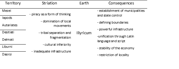
We now see that deterritorialization refers to the abandonment of existing one’s territory to form new sets through the permanent change “opinions, movements, articulations, framing and others ways of coexiste
nce”. Where deterritorialization is present, there are tendencies towards “order, border, codification, structure, stability, habits and constraints”. In addition to this form deterritorialization in the domain of social stratum, is possible recognized and other deterritorialized forms, e.g., paved path – road (via), boat – galley, border – limes, natural economy – commodity exchange, tumulus – stela, mine – municipium.
4.3 FIRST RETERITORIALIZATION: FROM NIS TO KRUSEVAC
The beginning of the medieval period was marked by parallel processes which took place for a century and a half (325–476) in the two most important cities of Rome empire. As Constantinople began to spring up in the east of the empire, the most famous and largest city in Europe for a long period of one millennium, eternal Rome began to fade, to lose strength under the blows of barbarians, and yes it finally collapsed as the center of the Western Roman Empire. With the fall of Rome, ends a long ancient period that lasted 13 centuries (from 8th BC to the 5th century), which was marked by the rise and fall of numerous Greek polises. As Greece ceased to exist as an independent state, but it is to its conquerors (Rome) conveyed its greatest values civilization), so Rome enabled the continuation of another millennium through the most valuable elements of its civilization (culture, faith, administration). This happened because it was just:
By merging Hellenistic culture and Christian religion with Roman state form, that historical phenomenon arose which we call the Byzantine Empire. That merger happened due to the shift of the center of gravity of the Roman Empire to the east, caused great crises of the 3rd century (Ostrogorski, 1998: 48).
Confirmation of this, he sees in the Christianization of the Roman Empire and the founding of a new capital on the Bosporus, thus beginning the Byzantine era. It was started by Emperor Constantine (born in today’s Nis), and on “Emperor” Lazar (the capital city of Krusevac) finished in our area, with which, conditionally, the medieval period of Christianity ends state organizations.
City
This great historical-geographical watershed between antiquity and the Middle Ages is visible in our area as a break urban development and road construction. These two great Roman achievements administration, were threatened by the invasion of barbarians (Huns, end of 4th and beginning in 5th century). Along with the state crisis in the west (Rome), it is getting stronger in the east Christianity (Byzantium). The great emperor Justinian I built The Empress’s city (Justinian Prima), rebuilds cities and builds new one’s fortifications on the limes and establishes bishops in the cities. In parallel with in the process, “Slavs will meet Christianity directly after immigrating to the Balkans, and that will be a world that is culturally, spiritually, and materially greatly altered in relation to the classical age of Roman civilization (Misic, 2014: 14). During medieval development recognizes the same elements of administrative-territorial organization in the studied area through existence two hierarchical levels for urban centers (squares and cities) and three levels for territories (parishes, regions and countries). The square is special settlement related to gathering in the open space for trade on one place on a particular day of the week and is different from the city square. They originated all over Serbia, mostly along the main caravans’ roads (Drina, Zeta, Bosnian) or near the coast. The most famous the squares were: Drijeva (Gabela on the Neretva), St. Srdj on Bojana, Hoca (Foca), but also squares near mining towns (Srebrenica, Novo Brdo, Zvornik, Fojnica). Cities played the most important role in the territorial organization of the state, and Constantine Porphyrogenitus (10th century) states in Serbia: Ston, Blagaj, Trebinje, Risan, Vrm (Klobuk) near Trebinje), Soli (Tuzla), Dostinik (Drsnik na Klini) and others. The towns and surroundings are governed by prefects, who are subordinate to the prince (ruler). Important cities had a special administration (Nis, Prizren, Skopje, Novo Brdo), which was managed by mullets (following the example of Byzantium). After the 12th century, according to the way of origin and the degree of communal development, Misic (2014: 82) on the territory of Serbia singled out five types of cities. The first group consists of cities in Primorje and Zeta which have ancient roots (Kotor, Shkodra, Ulcinj, Risan, Bar, Drivast, Danj, Sard, Cavtat and Ston). The second group consists of cities that Serbia conquered from Byzantium (Prizren, Skopje, Lipljan, Veles, Stip, Velbuzd, Nis, Ser). The third group includes the cities they belong to the origin and arrangement were influenced by the Saxons and the development of mining (Srebrenica, Novo Brdo, Fojnica, Olovo and Zvornik). The fourth group seems strong fortifications at important strategic points, which are often characterized absence of economic function or it develops within the suburbs.
One of the oldest cities of this type is Ras, and these are: Zvecan, Brvenik, Golubac, Soko (above the Piva and Tara formations), all towns in Polimlje (Milesevac, Kovin, Dobrun, etc.). The fifth group consists the youngest settlements, which developed independently after Kosovo battles. These include the capitals of Brankovic and Lazarevic: Krusevac, Smederevo, Belgrade, Stalac, Koprijan, Leskovac and Prokuplje.
Territory
In the domain of territorial organization, the lowest organizational the unit consisted of the parish. That was the basic administrative code of the Slavs territorial unit, and Blagojevic (1983: 45) believes that they are like this areas occupied, most often, by close or distant relatives, to whom it was “the easiest to organize, both for settlement and for work protection of common interests, as well as that such a community of relatives, at least in the beginning, they called the parish, and their elder the prefect „muscle (2019: 15) notes that Stojan Novakovic also noticed that one the parish consists of villages, and he considers that the definition of the content of one parishes should add “and at least one city or fortress.” Therefore, “the parish is an administrative and territorial unit that represents and rounded geographical whole, and the parishes are mostly spread in the river valleys and valleys, karst fields and plains, cultivated landscapes”. From this it is clear that the parishes were compact geographically wholes, separated according to the principle of homogeneity. Mostly they were river valleys (Ibar, Lab, Pliva), karst fields (Popovo, Dabar, Imota), plain and mountain areas (Branicevo, Gonji Ibar, Zeta, Podlimlje, Homolje), or cities (Brvenik, Prizren). He’s the mayor acquired the title by inheritance, and had jurisdiction in the field of judicial and administrative affairs. The administrative apparatus consisted of two other members: the cauldron (responsible for state finances) and tepcija (led the rulers) land Registry). The region is a specially organized territory in border areas of the Serbian state, composed of several parishes, and which was ruled by the lord of the Krajina. He was responsible for persecution of bandits and defense against incursions by the enemy army. This one Krajina between Rumija and Skadar Lake (Duklja – Byzantium), the mainland of Pagania (Serbia-Hungary), and they mention are also: Vranje region, Novo Brdo, Petrus and others. They are countries formed by the process of gathering several neighbouring parishes around one center. Some countries have managed to develop into states (Raska, Bosnia), and some have developed from old historical areas (Zeta, Trebinje, Hum). The earth was ruled by the powerful, and the spiritual authority was held by the bishops, because some countries originated in the area of spiritual jurisdiction of individuals episcopate (Raska, Hvostanska, Sremska, Moravicka, Branicevska, Limska, Toplicka). Some of the countries have expanded their scope (Hum), changed their name (Travunija), and some extended their name to neighbouring countries (Usora – Soli, Branicevo – Kucevo). Millennium the historical and geographical development of this area can be seen through three periods: early (5th – 10th century), developed (11th – 13th century) and late middle century (14th – 15th century).
Slovenian colonization, parishes and cities
The period of the early Middle Ages lasted from the immigration of Slavs to The Balkans until the creation of the first feudal states. At the beginning of the 6th century. Slavic tribes had already built a large number of settlements on the left on the banks of the Danube, between Djerdap and its mouth, so that it exists the Byzantine fortifications (mostly a continuation of the Roman cestrum’s) are not was sufficient to defend this frontier. The most famous fortifications, which are The Slavs won, they were: Ada Sapoja (between the mouths of Karas and Nera in the Danube), Ram (Djerdap) and Drobeta (Turn Severin). That conditioned Byzantine activity on the dynamic renewal and construction of fortifications on the Danube (Singidunum, Viminacium), but also in the interior Balkans (Remesiana, Ulpiana, Naisus). Slavs are constantly settling down throughout the Balkans and in doing so suppress, and in part and destroy the domicile population, which retreated towards Salona, Thessaloniki and, probably, Constantinople. Misic (2014: 17) notes that “after several centuries, this Romanized population appears on the historical stage under the name of Vlachs, Mavrovlas, Latins, Arbanas”. Settlement and distribution of Slavic tribes in the Balkans lasted for several decades, and permanent settlement could only be carried out the most numerous and well-organized groups, and they were certainly Serbs and Croats. They originally settled parts of Thrace, and then they settled moved to Pagania, Travunija, Zahumlje, Konavle and Serbia. “First historical data on Serbs come from Frankish sources in 822, when Ljudevit Posavski is mentioned, who is fleeing the Franks from Sisak and it takes refuge with the Serbs who hold a large part of Dalmatia” (Ibidem: 18).
The westernmost old Serbian country is Pagania, which stretched along the Adriatic coast, between the mouths of the Cetina and the Neretva. According to Porphyrogenitus[5], the people of Neretva had four fortified cities: Mokro (Makarska), Verulja, Vrulja Bay, but also today’s Gornja Brela), Osrtog (Zaostrog) and Slavinec (Gradac). Next to the island of Mljet, Korcula, Brac and Hvar, which settled in the VIII century, were Neretvans organized in three parishes. Rastoca and Mokra stretched along coast, and Dalena encompassed the interior space. South from Pagania, there was Zahumlje, which included the area from Neretva to Dubrovnik. It consisted of cities: Bona (Blagaj), Hum (unclear location), Ston on Peljesac, Mokriskik (perhaps a village Mokro in Mostarsko blato), Josli (village Oslje), Galumainik (village Glumine) and Dobriskik (Dabar village)[6]. They were in this area parishes: Ston, Popovo, Zabsko or Zazablje (around the mountain Zaba), Luka (lower Neretva), Dubrava (between Stolac and Mostar, valley of Bregava), Dabar (Dabar’s plain), Velika (area around Ljubuski), Gorimota – Imota (Imotsko plain) and Vecenike – Veceric (from the mouth Trebizat to Mostar mud along the right bank of the Neretva). Grassland stretched from Dubrovnik to Kotor, and had fortified cities: Trebinje, Vrm (Klobuk), Risan, Lukavete (spring Ljuta in Konavle) and Zetlivi (Gradac and the village of Zastolje in Konavle). According to the above According to the chronicle, this area was divided into parishes: Trebinje, Ljubomir, Fatnica, Rudine, Krusevica, Vrm, Risan, Dracevica (Hereceg hinterland Novi), Konavle and Zrnovnica (Dubrovnik Parish). The names of these the parishes are preserved and not difficult to locate. Duklja stretched from Kotor to Durres, and had fortified towns: Gradac, Novigrad and Lontodokla (none can be killed with certainty). They are parishes were located around Skadar Lake (Luska, Podluzje, Kupelnik, Crmnica, Gorska and Oblik) and on the coast (Prapratna, Kuceva and Grbalj). The chronicle also mentions Podgorje as a special area, within which parishes were located: Onogost (Niksic), Moraca, Komarnica, Piva, Gacko, Nevesinje, Neretva, Rama, Viseva, Idbar (Prenj) and Kom (Glavaticevo). These parishes later belonged to Zeta, Raska, Bosnia and Hum country.
Serbia is bordered on the south by Duklja and Travunija and, probably, parishes mentioned in Podgorje. Northern border Porphyrogenite it is not mentioned directly, but is considered to have been on the Sava and Danube. On the to the west, the Vrbas valley belonged to Serbia, and the border with Croatia was between Cetina, Livno and Pliva. The eastern border was obscure, and probably included the valleys of the Ibar, West Moravia and Kolubara. The inhabited cities were: Ras (near Novi Pazar), Destinik (village Drsnik na Klini), Cernavusk (parish Crna Stena near Prijepolje), Medjurjecje (possibly the town of Soko near Piva and Tara) or near Ustipraca), Dresneik (Dreznik near Uzice or Pljevlja), Lesnik (Lesnica in Jadar) and Salines (Tuzla), and Kotor (Kotorac near Sarajevo) and Desnik (Sutjeska near Kakanj). The chronicle mentions that Surbia (Serbia) divides into Bosnia (from Borova planina to Drina) and Ras (from Drina to Lab and Lipljan). State organization of this area it was not solid then and is considered to be Serbia (after the death of the prince Caslava) suffered prolonged pressure from Bulgaria and Byzantium, such as Hungary subjugated Croatia, the western part of Serbia, and Bosnia (beginning of the 12th century). In the administrative organization, several parishes formed is a larger whole – countries (Drinska, Limska, Moravica, Soli and Usora, Srem), which will subsequently become independent and form special one’s countries (Raska, Bosnia). The process of gathering, separating and grouping these areas – countries – states, with changing pressures from outside (Hungary, Byzantium), lasted from 9th to the end of 11th century, when strongly Raska and Bosnia rise.
From a historical-geographical point of view, in the studied area, the early Middle Ages were marked by Slavic colonization, which has achieved the complete dominance of its demographic mass, and the rest it assimilated the Romanized and Germanized population. The main features of this area, according to Rogić (1982: 77-78), are reduced are on two dominant processes. The first is political-geographical the division between the first autochthonous Slovenian political-territorial centers (which took place and continued to develop) and the rest of the vast belt of domination of the Slavic population without strong own organizations (Sclavinija, Slavonia or Slovinja). The second determinant is the complex process of shaping a new type of rural cultural landscapes that are performed as part of natural-economic relationships. It is a space without city centers, developed trade exchanges and without established road communications and traffic. The only exception is the preserved and restored Adriatic cities, which they exchange livestock and forest products with neighbouring Italy. Geographical influences of these remnants of the developed ancient trade exchanges contributed to the strengthening of the first autochthonous Slovenian cores political-territorial units in the hinterland of Dalmatia Romanesque cities (Dubrovnik, Split, Trogir, Zadar) and three main one’s island centers: Osor[7], Krk and Rab.
Developed Middle Ages: First states and first heterotopia
To clarify the significance and crucial importance of this phase in historical-geographical development of our space, it is necessary to shed additional light on general cultural and geographical circumstances. The start this period was marked by a great schism or schism in the Christian church (1054). This act was preceded by centuries of controversy around various theological-dogmatic and church-administrative issues, and the consequence was the severance of communion between the Roman Catholics and the Orthodox Church. The main theological dispute concerned the West teaching about the double outpouring of the Holy Spirit from the “Father and the Son” or in short described as filioque (Filioque lat. conjunction “and”), which is not accepted by Eastern Christians. Another big reason (church administration) was related to the violation of the principle of church catholicity, ie. the ambition of the Roman Church (the pope) to impose his authority on the whole to the Christian world. This event will strongly mark the character of all “misunderstandings” on the West-Balkans route, which last in full millennium, and are recognized in numerous processes, from the Crusades wars to the politics of proselytism[8]. It is from this perspective, The Balkans are “through the eyes of the West” (Vatican, Venice, Austria, Hungary) viewed as a different space. In postmodern language, we could do that describe by Foucault the term heterotopia or transition state for which is a characteristic socially unacceptable behaviour, ie. a place that disturbs the established order and principles of civilization.
At the same time, E. Soja labelled this term of Foucault’s as the Third Space which is proof of the inventiveness of a colourful world. During the developed Middle Ages there was a complex development and strengthening the feudal-aristocratic economic structure and a new type political-geographical differentiation of this space. That conditioned transformation of the cultural landscape of the previous period, based on which Rogić (1982: 84-92) recognizes six Slavic autochthonous political-territorial cores that completely change their own historical-geographical significance. For us, four are especially important, which represent specific political-territorial units: Raska, Bosnia, Adriatic and Pannonian area. At the end of the 11th century. rulers of Raska they pursue an active anti-Byzantine policy with the desire to expand their own possessions to the southeast towards Kosovo and southern Pomoravlje. Border with Byzantium it was on the field of Kosovo, between fortified cities Zvecan (Serbia) and Lipljan (Byzantium). On several occasions (1093 – 1106) managed to conquer Lipljan and expand their influence to the south and east to southern Pomoravlje. Thus, she found herself fertile within the state the parish of Morava (between Cacak and Kraljevo), as well as the parishes of Lab and Toplica and Rasina, which leads to the strengthening of the Serbian ethnic consciousness in the valley of Velika Morava, Kosovo and Metohija. In the second half of 12th century the holy dynasty of Nemanjic is established, which will be under by the strong influence of Byzantium. Conflict of Byzantium and Venice (1171) The monks will use it to consolidate their power, and in this one period, earlier cities, in part, lost in importance (Ras, Novo Brdo, Zvecan). From the former ancient cities, it will again greater importance in the southeast of Nis, Prizren, Skopje and Lipjan, a on the coast (Duklja): Shkodra, Bar, Ulcinj, Kotor and Budva. Within the mountain core, and as a new political-territorial hotspot, during the 10th century Bosnia is mentioned for the first time. It was not state category, but a geographical area along the eponymous river from Vranduk to the Sava, with a tribal warrior-livestock organization. During the reign of King Bodin, Bosnia recognized the rule of Duklja, after whose death begins the independent development of this country “which the Drina separates from other Serbia”[9]. This was a geographically unrelated space within which differed in the areas of Bosnia, Usora, Soli and Donji Kraji. The processes of shaping cultural landscapes have been slow and stronger agricultural production took place in fragments. They occur sporadically important mining towns below Vranica (Fojnica, Kresevo, Dusina, Busovaca) and in the middle Podrinje (Srebrenica, Sasi, Cagalj). The main trade centers are emerging in central Bosnia (Bobovac, Podvisoki, Travnik and Gradac), Podrinje (Foca, Gorazde and Visegrad), on Sana (Kljuc), Vrbas (Jajce) and Neretva (Konjic).
Within the Adriatic area, the geographical concept of Dalmatia is expanding to cities and their agrarian area, and their number is expanding with several coastal towns and to the hinterland. Old and new settlements firmly are functionally related to the agrarian environment, and characteristic Mediterranean agricultural landscapes (manual processing of cereals and vegetable crops) cover the area of former antiquities ager, but also new surfaces. Such a space is a flysch zone inside the central Dalmatian coast from Siget to Stobrec with Zagora, as a belt of the most favourable conditions of traditional agrarian valorisation on the site of the old and most important ancient ager between Trogir and Split. Nevertheless, the economic and cultural significance of Adriatic cities it is closely linked to the development of trade between Europe and the Middle East, and a good example is Dubrovnik, which is achieving a successful transit-trade activity in the field of maritime affairs (Venice and Byzantium) and caravan land trade (predominantly according to mines and cities of Bosnia and Serbia). This traffic-trade the activity leads to the strengthening of the economy and the expansion of the city territory to the neighbouring islands and terrains between Konavle and Peljesac. The Pannonian and Peri Pannonian area is a wide area within which two geographical regions stand out: eastern and western. During of the developed Middle Ages, the eastern parts of the vast steppe the area is characterized, in economic terms, by mobile livestock. The transition to field production was a stabilization settlement and the safety of production conditions guaranteed only by strong political power. The predominance of these mobile livestock groups is not during this period provided such a development, so is the existence fortified and strong cities remained unknown, except in the Danube belt (Bac, Sarengrad, Slankamen, Ilok). In the western part Pannonian and peri Pannonian areas, historical-geographical conditions enabled the gradual transformation of old Slovenia (Slavonia) into the new and leading political-territorial core of Croatia. It is the result of a new feudal organization with royal counties and established headquarters of the administrative organization (former Roman castrum). Their political affirmation is made possible by development traditional agrarian multicultural economics. Inside this fortified city – burgs are created in the area, and the most important are: Zagreb, Varazdin, Virovitica, Vukovar, Osijek, Krizevci, Pozega and Djakovo. As the number of these burgs declined from west to east, it is logical to conclude that the reasons for this are political-geographical nature (Pannonian Plain, Kingdom of Hungary, Catholic Church, absence of external enemies), historical and demographic factors (number, density, distribution), economic and social transformation cultural landscapes (cattle breeders, farmers) based on economic strength (trade) and administrative-territorial organization of space (early feudal relations). In the spatial structure of a medieval city the dominant fortification (defensive) elements are recognized arranged in two rows (outer and inner), and dominant the facilities are: towers and a citadel (a space for accommodating soldiers which is good connected to other parts of the castle and allows movement along the top defensive wall and has a serrated fence and the function of a parapet on top of the defensive wall). The end of the external defense of the castle represents entrance gate (closed by a large and massive lattice) with a defensive one tower. The internal fortification elements are: internal defensive area of the castle, pedestrian and drawbridge and dungeon or central tower. These elements were also present in the cities of our spaces. A system of earthworks was often built around the city fortifications that hindered the movement of the enemy, and mostly they consisted of: wooden fences (palisades), canals filled with water or wide trenches (trenches).
Late Middle Ages: Roads and cities
During this period, different types of cities developed under dominant cultural influences from neighbouring areas. In the southeast, urban centers are emerging under the influence of the Byzantine of the urban phenomenon, and in the northwest, these are the influences of Central Europe urban area. They develop in the central mountain area are urban centers with transitional features of these two types, but it is physiognomically and functionally (royal fortification, suburbs with different groups of merchants), closer to the Byzantine type. That can be seen through the existence of colonies of merchants (Dubrovnik), as well as the dominant significance of mining and the specific caravan trade. As part of new political entities, new cities are being built, and the meaning of individual centers changes spatially over time. Core new urban development rested on new foundations, functions and within a new society characterized by an intense demographic development, which leads to the emergence of a new social class, whose position is not was clearly defined within the inflexible organization of the feudal society. The main building material in the medieval city was wood, and only representative, sacral and public city buildings, and rare houses, were built of stone. Fortification elements they marked the space of political power of the city and physically separated it city from the surrounding area. Inside them, in protected areas, a new form of social, cultural and economic life developed. The specificity of the defense system is its asymmetry and adjusting to terrain configuration. Inside this enclosure the space created an irregular network of streets, as a consequence spontaneous development and physical-geographical features of the city land. In the newly formed cities, Rogić (1982: 97) states that to them, regardless of their core and type of city (Central European or Byzantine), a common feature of “underdeveloped strength autochthonous emerging bourgeois economic initiatives”. That the initiative is strongly developed and maintained only by Adriatic cities, and especially Dubrovnik, as the most developed business center. His social development is marked by the emergence of a kind of organization aristocratic republics, as internal social differentiations urban population. Dubrovnik is the best example of the coast the city that developed the functions of the main center of polarization economic life for most of the interior, making it his gravitational influence covered the entire area of Serbia and Bosnia, and was felt in Bulgaria and Romania as well. The most important products that are were exported from this area via Dubrovnik were: live cattle, game skin (deer, wolf, rabbit, marten), wax, honey, specific wood products (oars), but also coarse fabrics. Because of the unfavourable relationship value and weight of goods, cereals were not exported. Chief imported items were: with and finished more valuable products (weapons, handicraft products and luxury goods). Demographic specificity development in this period were also a kind of forced migration population due to religious freedoms, ie. expulsion of members Bogomils communities that were numerous on the territory of today’s BiH. It was the result of the policies of Roman popes and Hungarian kings, who considered them “heretics” and led a crusade against them war and forcibly baptized them. The interpretation by which they are is wrong only these inhabitants were buried under massive stone slabs (stecak tombstones), which are the most numerous on the territory of BiH. It’s important here mention the importance of Bosnia in the history of Serbian statehood, which he writes about Blagojevic (2011), who no leaves possibilities “for the existence of Bosnians who are not Serbs”. He states that its ruler bears the title of ban, and existence “Share of rulers, convicts and thugs, is the same as in Serbia” is under the rule of Hungary and Byzantium. He notes that the bans are their own the subjects were called Serbs.
Cultural heritage of the Middle Ages: Historical-geographical consequences
From numerous and different cultural traces from the medieval period, with their significance and number, the sacral ones stand out (church) monuments. These are the most visible remains of the monument heritage of the Middle Ages, which were built in different historical styles and most often reflect the unity of cultural stimuli, who came from the surrounding area (Byzantium, Venice, Hungary), with specifics of local political and cultural (religious) development. They still capture our attention today with their original’s architectural solutions, which we also recognize as historical styles. Monuments from the period of late antiquity were discovered on the territory of BiH (up to 476) and the early Christian period (200-500 / 700), which, for the most part, belong to Byzantine art. The largest number are churches from 5th to 6th century, which are located in several localities. The largest in central Bosnia number was discovered in the vicinity of Travnik (Turbe, Veliki and Mali Mosunj, Oborci), Kresevo (on the hill Gradac), Vares (village Dabravine), and at Zenica and Breza. Remains of churches in Duvno have been found in western Bosnia (site of the Roman Delminium), Bihac (village Zalozje), Kotor Varos (village of Siprage), Mrkonjic Grad (village of Majdan), and in the east part, the most important locality is Skelani. On the territory of Herzegovina, the most significant remains of churches were found in the vicinity of Stolac (village Vidostak and Blagaj), Vitina (village Borasi), Capljina (Mogorjelo and the village of Tasovcici) and Mostar (the village of Potoci).
Of similar monuments from of the same period, the greatest importance on the territory of today’s Serbia is played by Caricin town or Justiniana Prima (Lebane) and Ulpiana (between Gracanica, Pristina and Lipjan). In the Moraca and Zeta basins and around Skadar Lake, there was Duklja (Doklea), which has been called Zeta since the 11th century. The center there was Doklea (near Podgorica), in which there were several basilicas, and a glass was found there. Significant churches were also in the village Doljani (Podgorica), the village of Topolnica (Bar), the village of Gotovusa (Pljevlja). On the soil of the Adriatic coast, two localities were of the greatest importance which, in addition to the predominantly Byzantine ones, also had stylistic determinants pre-Romanesque. Istria was ruled by Ravenna (Byzantine exarchate), and the most significant monuments are the Euphrasia Basilica in Porec, churches and mosaics in Pula, Fazana, Vrsar and Brioni. The second site is central Dalmatia, and the largest number of monuments was is in ancient Salona (the most famous basilica of Constantine), but also in Trogir, Zadar, Drnis and Sinj. However, the most monumental churches, in Byzantine style (9th – 14th century), were built in the area of Vardar Macedonia and are connected to the Byzantine Ohrid Archbishop. The most beautiful examples of these churches are in Ohrid and its surroundings: St. Naum, St. Sofia, St. Panteleimon, St. Jovan Kaneo. Great importance for the development of art in our area represented is the penetration of new artistic achievements (11th century) which is called romance. This art is recognized in church architecture by a number of peculiarities, from the manner of construction to the general assembly.
Next to monumentality, the characteristic form is the three-aisled basilica in in the form of an elongated (Latin) cross, and examples of this construction are found on the Adriatic coast and in Raska (mostly in the 13th century). Certain Romanesque elements can be recognized on the stecak tombstones (cross, arches, sun, crescent, etc.). Slightly more numerous Romanesque monuments arts exist on the coast, and are considered representative Cathedral of St. Stosije in Zadar, cathedral in Split, portal (entrance) Cathedral in Trogir, the church of St. Trifun in Kotor and others. For development of this style the most deserving are the Benedictine monks of southern Italy (Monte Cassano), who were the greatest builders of such churches on our space. These churches will leave a significant mark on architecture and Serbian monuments in the interior of Raska. At the beginning of the 13th century the Gothic style appears. Similar to the previous one, there is only one on the territory of BiH fragments on cultural monuments built in this style. The recognizability of this style is made by buttresses or supports arches, broken or pointed arch and cross-ribbed vault. In this style was built the roof of the monastery of Kraljeva Sutjeska, on which buttresses are recognized. They can also be recognized on the stecak tombstones some decorative elements indicating Gothic art (pointed bow, horsemen, shield, sword, lily).
In the territories of today’s states of Serbia, Bosnia and Herzegovina, Montenegro and in part Croatia, in this period was the dominant Byzantine art, ie. old Serbian church architecture. Numerous churches and monasteries of the Serbian Orthodox Church, as the most important monuments of this period. For many of them there is no accurate data on construction or renewed, but on the basis of written documents a picture of the existence of these most important monuments of the Middle Ages, which have triple artistic value. First, they are important as architectural monuments that are built of different materials and in different styles. The second value is painting, because most of these monuments were painted by the greatest painters of that time (e.g., Longin and Georgie Mitrofanovic), and painting compositions on the walls they were made using the fresco painting technique and a significant number of frescoes have been preserved till today. In addition to frescoes, icons were also made (most often plays saints on wood using the oil paint technique), which have the largest museum value and are found in numerous church and folk museums throughout BiH, the most important of which are: The Museum of the Old Orthodox Church in Bascarsija (Sarajevo) and the museum collection Karadjordjev konak within the monastery Dobrun (Visegrad). They have a third value art objects that represent the result of filigree decorations and various miniatures (wooden and metal crosses that are decorated with precious metals), carvings, iconostasis, royal doors), church utensils that are beautifully worked and decorated (candlesticks, chalices, goblets), various pieces of clothing and equipment bishop (sceptre, panagia, mitre). According to stylistic features and way of building church buildings, Simic (2000: 163) shares this time span of Serbian church architecture in five periods: prenemanjic, Nemanjic, Milutin’s age, Morava’s school and period of Turkish occupation.
The Prenemanjic period is characteristic of two Serbian areas. In the first, which consists of Zeta, Zahumlje and part of the coast, they were formed monuments from the beginning of IX to the end of XII c. Significant monuments these groups are: Church of St. Peter in Cicevo (near Trebinje), Church of St. Mihovil (Ston), Church of the Immaculate Conception (Skadar Lake), Monastery of St. Srdj and Vakha (near Shkodra), Monastery of St. archangel Mihailo (Prevlaka near Tivat). The second area seems continental part of the Serbian state, and the most important monuments are from the period 10th – 12th century. The church of St. Peter and Paul (Ras – Novi Pazar), in which Stefan Nemanja (the ancestor of the saint of the Nemanjic dynasty). Of great importance is the church of St. Petar (Bijelo Polje), the seat of the bishops of Hum, where the oldest is located founder’s inscription of a Serbian ruler (Prince Miroslav, Nemanja’s brother). Of the other monuments, we will mention the Zanjevac Church at Zajecar and the church in Djunis.
The second period is called Nemanjic or Raska school, and “these churches were built according to the general Orthodox Byzantine conception, but are externally treated in a Romanesque way and they were called the Raska style group” (Simic, 2000: 164). This one the group also includes several monuments from a later period, such as are: Banjska, Decani and St. archangels near Prizren. From this description it is evident that the churches of Raska are a reflection of the symbiosis of the eastern and the western ways of building, and some of the most important churches built by Stefan Nemanja are: St. Bogorodica (Kursumlija), Djurdjevi stupovi (above Ras, near Novi Pazar) and Studenica (three churches near Usce on the Ibar). The monastery of Zica (Kraljevo) was built by king Stefan the First-Crowned with his brother St. Sava. Mileseva near Prijepolje was built by the king Vladislav (son of Stefan the First-Crowned), and the founder of the Moraca monastery (Zeta) was Prince Stefan (Vukan’s son). Sopocani (at the source of Raska near Novi Pazar), was built by King Uros I, and the Gradac monastery Raska) is the endowment of Queen Jelena of Anjou, the wife of King Uros I). The Banjska monastery is the main endowment of King Milutin, it belongs the following period, but the façade was treated in a Romanesque way, as well near Decani (started by King Stefan of Decani, and finished by his son Tsar Dusan) and St. archangel (the main endowment of Tsar Dusan).
Age of King Milutin (Serbian-Byzantine style group) it is characteristic for the period of the 14th century, when it was in the Serbian church architecture has undergone a major change since then, unlike Raska monuments, churches are built on the example of Byzantine models (in in the form of an inscribed cross). “This change was due to expansion the borders of the Serbian state to the south, which did not cross Lipljan for a long time on Kosovo. King Milutin liberated Skopje, Stip, Polog and was is not only a great ruler but also our greatest church builder” (Ibidem: 233). His continued expansion of the Serbian state, he continued Tsar Dusan, who occupied the whole of Macedonia, Epirus and Thessaly, the whole space to Corinth. After that, he was proclaimed king of the Serbs, Greeks, Bulgarians and Arbanas (in Skopje, on Easter 1346). The most beautiful example of this group is the monastery of Gracanica (Kosovo), which is always taken as an example of the Serbian-Byzantine style. The most important monuments built in this style are: The Patriarchate of Pec (three churches), the Church St. Dimitrije (Pec), Church of St. Hodegetria (Pec), Milutin’s church (Holy Mother of God) in Hilandar (Holy Mountain), Mother of God Ljeviska (Prizren), Studenica (King’s Church) and St. Nikola (near Priboj).
By liberating these southern parts of our country and Macedonia from Byzantine authorities found themselves on the territory of the Serbian state many Byzantine churches that stood out for their beauty. The Serbs are now even more closely related to the Byzantine spiritual heritage and for the renewal of existing ones, as well as for the construction of new one’s churches, the founders took Greek and local masters, and less and less they were looking for them in Primorje. The monuments of this group have all the features of the Byzantine style, which were rectangular in shape, with inscribed with a cross and one or five domes (Ibidem: 234).
The Moravian style group developed after the collapse of Serbian empire (1389). The Turks first conquered the southern regions, while they were on north and in Pomoravlje (the state of Prince Lazar, his son Stefan Lazarevic and granddaughter by daughter, despot Djurdje Brankovic), held until the fall of Smederevo (1459), when Serbia was definitely conquered. The central area of this state was located in the Morava basin (Velika, South and West), with the capitals of Krusevac, Belgrade and Smederevo. Although Serbian despots had to fight constantly, sometimes and on the side of the Turks, the old tradition of building churches and monasteries and it was further maintained. In these unfavourable circumstances, a large one was built number of churches, in their style the most original and most Serbian in our medieval architecture. The main monuments of this group are: Ravanica (near Cuprija), Lazarica (Krusevac), Ljubostinja and Kalenic (near Trstenik), Manasija (or Resava, near Despotovac) and etc. During the Turkish rule, the building and decorating of churches became it is very difficult, but it has not stopped. The need to build churches was is deeply ingrained in the consciousness of our people and new, insufficiently strong founders, aware of the impossibility of creating new large architectural works, in simplified forms continue the old architecture of their glorious ancestors.
The basic characteristics of Moravian churches are: the shape of what is inscribed cross, choir apses taken from the architecture of Mount Athos, which with the altar apse they form a trichions (trefoil), one or five domes, larger churches were built without a western narthex, which is theirs subsequently added, and the smaller ones are always built with a separate narthex from a nave full wall. The most original is the exterior finish of the facade, which is divided horizontally and vertically by stone outlets (Ibidem: 277).
The fifth period refers to the time of the Turkish occupation. They are Turks forbade the construction of new churches unless it was in place of the old one’s churches that existed before their arrival. Also, according to legend, they conditioned their height (they must be lower than the surrounding mosques), and their width should not exceed the size of a bull’s skin. Therefore, they are the founders, in order to obtain a building permit, proved that it was a church existed where it did not exist, hence many churches of this period, by tradition, they are considered non-monastic endowments. Example local resourcefulness are the builders of the Old Church in Sarajevo. She is buried in the field, so that the height does not exceed the surrounding objects, and its size they determined with ox-skin which they cut into narrow strips and so on skin maximally expanded. This whole period in the history of Serbia art, is divided into three periods[10]. The most difficult building conditions they were in the first period, and a somewhat more intensive activity existed was then only in Herzegovina (the monastery Tvrdos was built and more small churches). After the renewal of the Patriarchate of Peja, more favourable conditions they enabled the renovation and erection of churches and monasteries throughout area of the patriarchate in the form of a group of monasteries: Fruska Gora, Podrinje, Ovcar – Kablar, monasteries in Slavonia and Croatia, Old Herzegovina, Bosnia, Macedonia.
Some of these groups’ monasteries became important religious and cultural centers, famous as holy mountains, the most famous of which are Fruska Gora and Ovcar – Kablar valley. Since there were no wealthy individuals during this period, the founders of the most important monasteries were metropolitan, tribal princes, spahije-Christians, abbots with the monastery fraternity, wealthier craftsmen, and most often the locals themselves (Ibidem: 299).
According to the monk Ignatius (Markovic, 2010), on the territory of BiH today there are twenty-nine living monasteries, most of which are originated during the medieval period, and only four were created recently. For some of them, there are no reliable historical indicators about the time of construction, so we will count them and point out the historical surrender. The most significant monuments from this period on the ground today BiH can be divided into three geographical units (Herzegovina, Krajina, Podrinje), but it is more correct to divide them according to the current one’s dioceses. On the territory of the Dabro-Bosnian metropolitan, there are monasteries Dobrun, Vozucica and Gostovic (mountain Ozren near Doboj), and near Sokolac is the monastery Knezina. Near the present monastery, according to folklore, the original church was built on its foundations a second religious building was subsequently built. “Tradition says it is the monastery was built by Andrijas Mrnjavcevic, brother of Marko Kraljevic, in 14th century” (Ibidem). In addition to these numerous monasteries, there are on the territory of BiH and churches, most of which were built during the 19th and 20th centuries. Still, one of the oldest and most valuable testimonies of history, duration and cultural uplift of Serbs in the area of Sarajevo is the Old Orthodox church in Bascarsija. According to tradition, it was built by the aforementioned Andrijas, during the 14th century, and Turkish defters (censuses) from the end of the 15th century. mention the number Christian and Muslim houses, and the priest’s son. It is considered to be an existing church built on the foundations of an older church.
The dioceses of Zahumlje-Herzegovina and Primorska have the most numerous and the most valuable monuments from this period, and they are: the monastery Tvrdos and Church of St. Michael at the cemetery in Arandjelovo (near Trebinje), monastery Zavala (Popovo polje), Zitomislic Monastery (near Mostar), Church of St. Nikola in Srdjevici (Gacko), Trijebanj monastery (code Livestock). Existence of the Duzi Monastery and the Peter and Paul Monastery (near Trebinje) “mentions the Chronicle of the priest Dukljanin (12th century), a legend connects these monasteries with early Christian basilicas and the missionary journey of the Apostle Paul” (Ibidem). It is similar with Dobricevo monastery, which legend says “was built by the emperor Constantine, and the monastery seals from 1232 and 1283 were found” (Ibidem). The founders of the Tvrdos monastery were Metropolitans Visarion and Jovan, and the painting was done by Vicko Lovrov from Dubrovnik. Founders of the Zitomislic monastery are spahija Miloradovic and Nevesinje dukes from the family Miloradovic Hrabren, and part of the interior the works were made by master Radul. The most valuable paintings on he painted several Herzegovinian churches (Dobricevo and Zavala) is the Hilandar monk Grigorije Mitrofanovic. Some of these monasteries were built on the foundations of early Christian basilicas from the period 4th – 6th century, e.g., Tvrdos monastery, as evidenced by the foundations which were seen under the glass plates on the floor of the church. Due to the construction of HPP Grncarevo, the Dobricevo monastery was completely transferred to the new one location in the village of Orah.
The most important monasteries of the Banja Luka diocese are: Gomionica and Krupa on Vrbas (near Banja Luka), Mostanica (near Dubica), Stuplje (near Prnjavor) and Liplje (near Teslic). It is considered to be King Dragutin founder of the Liplje monastery, that many monasteries were destroyed after the arrival of the Turks, and the monks expelled, e.g., such is the monastery Stuplje, whose foundations were discovered only in 1994 and then on them the present monastery was built. In the diocese of Bihac – Petrovac there are three monasteries: Rmanj (near Martin Brod), Glogovac (near Sipovo) and Klisina (near Prijedor). The most important monasteries The Zvornik-Tuzla dioceses are: the Ozren monastery, which is located on the mountain of the same name, is one of the largest in this region, he mentions at the end of the 15th century; Tavna Monastery, located near Bijeljina, and monasteries of St. Archangel Gabriel (near Ugljevik), Lovnica and Papraca (near Sekovici) and Sase (near Srebrenica). As the founder of these monasteries King Dragutin is mentioned with his sons Vladislav and Uros.
When it comes to the medieval cultural heritage of the Roman Catholic churches on the territory of BiH, it is many times smaller in number of monuments in relation to the monumental heritage of the Serbian Orthodox Church. The oldest Catholic institution in BiH is the diocese of Tribune based in Trebinje.
It happened somewhere in the second half of the turbulent tenth century. In 1089, the diocese of Trebinje was submitted to the metropolitan in Bar. Before the arrival of the Turks, a large part of the Catholics of this diocese he moved to Dubrovnik. The oldest written mention of Bosnia diocese based in the area of today’s Sarajevo is a bull antipope Clement III from 1089. by which this diocese as the already existing one is subjected to the metropolitans of the Archdiocese of Bar (Zovkic, 2012: 127).
One of the first Catholic churches in BiH was built in 1244, „Cathedral of St. Peter in the parish of Vrhbosna, on the Hill” (Ibidem: 128). Bosnian bishops transferred their seat from Vrhbosna to Djakovo (Slavonia) in 1252 and from there they managed the diocese all until the establishment of the vicariate in Bosnia in 1735. For religious life Catholics in BiH during this period, the Franciscans are the most deserving. It is an order founded by Francis of Assisi (13th century) and who came to Bosnia in 1291. “They were formed into the Bosnian Vicariate in 1340, which is due to political circumstances under Ottoman rule in 1514 divided into Bosnia and Croatia, but as early as 1517 they were raised to the level of separate province” (Ibidem: 151). The first Franciscan monastery was built in Immediately after their arrival in BiH and in that city, Srebrenica gave name of its province Bosna Srebrena (Bosnia Argentina). First the monks were Germans, Italians and Hungarians, and their arrival ties to the miners of Sase (Saxons, come to Bosnia for mining).
Material sources that indicate the development of social processes during the Middle Ages in the area of today’s BiH they are very rare. This refers to written documents, on the basis of which it was created and historical-geographical picture of this space. In addition to the mentioned work Constantine VII Porphyrogenitus “On the management of the state” (De administrando imperio) from the 10th century, the most important domestic source is the Ljetopis popa Dukljanina or Barski rodoslov by an unknown author from the 12th century. Glagolitic is the first Slavic alphabet, and its compiler is Constantine Philosopher, one of the holy brothers of Thessaloniki, the founder of the Slavic one literacy. Samardzic (2015) states that in medieval Bosnia, Glagolitic present since 10th century in the form of “round, angular or semi-round Glagolitic – which characterizes the Bosnian medieval monuments, as a variant of the Glagolitic system of letters”. Famous Glagolitic monuments are: Hrvoje’s missal, Grskovic’s and Mihanovic’s excerpt, Split excerpt from the 13th century. Remains of the Glagolitic alphabet are also found on epigraphic monuments from the earliest period, such as inscription from the Monastery near Gradiska (10th – 11th century), symbol of Kulin’s plates (12th – 13th century). etc. Cyrillic is the second Slavic alphabet, and it is considered it is said that its compiler was Kliment Ohrid’s. It was created in the 10th century on the ground Samuel’s state. Samardzic states that there are three Cyrillic groups literacy, of which the most important are from the first group (church books) documents Miroslav’s Gospel (written at the end of the 12th century in Hum) and the Teapot Gospel (written before 1415). Another group of monuments consists of acts of administrative and legal nature, of which it stands out Charter of Kulin Ban from 1189, and from the monument of the third group (epigraphic monuments), these are inscriptions on tombstones. The oldest the preserved Cyrillic inscription from the territory of BiH is the Humacka ploca, a in addition to writing, it is important to mention language. In the period 10th – 19th century, ie. from Constantine and Cyril to Vuk, Samardzic (2019: 69) states that among the Serbs, in addition to the vernacular Serbian language, they were also in use four literary languages[11]. In the domain of cultural incentives that have developed in the environment of BiH, it is important to note the beginning of humanism on the Adriatic coast (Dubrovnik). It referred to various area’s creativity and culture, and under his influence he changed worldview. Its source was in the restoration of ancient ideals in all spheres of thought. It was short-lived and arose as a reflection on the influences of Italian models, but it was not transferred to the territory of BiH. That which has the greatest cultural value, and has been transmitted and remained permanently, it is an architectural heritage of bright models, embodied in Serbian church heritage.
After an extensive review of medieval historical-geographical content within the studied area (colonization of Slavs, the emergence of Christianity and the alphabet, the formation of nation-states, theirs rise and eventual decline under Ottoman rule), changes in spatial the structure of the studied territory can be seen more clearly in the light geophilosophy, ie. the process of its first reterritorialization. She is a consequence of the action of various forces “chaos, disorder, variation, liberation, mobility and infinity”, which they produced new political-geographical reality, ie. creation of the first Slavic political-territorial communities. In the domain of the influence of these forces in the space-time system, we recognize the most significant changes in the domain of population. The process of ethnogenesis within the complex Slavic stratum (probably also members of other ethnic groups communities: Avars, Huns, Scythians, Goths …) and indigenous population (Illyrian tribes), the differentiation of individuals began cultural groups, which will, after a long period of construction (peak will be the formation of a nation-state) become nations. In domain space, there will be a constant differentiation and change of name, and with a clear idea to achieve three goals: defense against external aggression (Hungary or Byzantium), more efficient state administration and implementation identity issues (the connection between the state, religion and people). It can be seen on examples of all political-territorial taxonomic units, from Pannonia and Dalmatia (Illyricum) to the Slavic communities (from parishes and regions to the country and the state). Changes in the domain of the term time we have already described (see section 2.2.1), but we emphasize once again that epochal novelty that led from the “captive circle of cyclicity” (antiquity) in “linear progression of time” (Christianity) in which history has a beginning, a duration and an end.
General impression of this millennial period and the reasons for its downfall The Roman Empire is not unequivocal. From a geographical point of view, it imposes is the fact of changing vital statistics. Birth rate the inhabitants of Rome were in decline, as opposed to the increased natural growing peoples who besieged the limes and sought a way to occupy them richer countries. Normally, the internal weaknesses of the kingdom are only accelerated the process of disintegration, which left great historical-geographical consequences. On the one hand, it was a significant drop in the general level knowledge and perception of the world, accompanied by the absence of technical knowledge and lack of capacity for quality state organization. It will take the Slavs four centuries to create the first outlines of the states on the soil of the former Illyricum, whereby the infrastructural the basis of these newly formed states, to a large extent, constitute the Roman heritage (roads, cities, mines …).
| Earth | Smoothness | Territory | Consequences |
| Illyricum | -barbarian incursions and disorder, -variation of birth rate -chaos after the fall of Rome, -military mobility, – the idea of liberation through state superiority -the idea of infinity in forms of cyclic time | Raska Duklja Bosnia Herzegovina Slavonia | -stabilization of settlements -population growth and assimilation -the first state-building Slavic communities -agrarian mobility – the Christian idea of salvation and eternal life – time as a linear movement towards the end of the world |
The second dimension is represented by spiritual representations as sublime Christian ideals. In the domain of scientific knowledge, based on dogma, geographical representations had a significantly lower level than ancient one’s patterns. The Latin alphabet was lost, and the arrival of Cyril and Methodius will happen only in the IX century. She began to slowly build awareness of being alone the strongest and best organized cultural groups can survive, and therefore they needed a state. The Serbs did it first and they did it the longest and best, in the environment. At stake, we discern these consequences and on the basis of numerous examples, reterritorialized notions, and which we can recognize in the elements of urban and political geography: kingdom – province, city – market, army – disorganized groups, castrum – village, limes – ruin, via – caravan road.
4.4 SECOND DETERITORIALIZATION AND SECOND HETEROTOPY: FROM KOSOVO TO BERLIN
The end of the medieval period will mark the emergence, development and the expansion of the Ottoman Empire in south-eastern Europe, which will end independent development of our states, to subdue them and thus impose another cultural-civilizational framework over the next four centuries. It will be in the millennial state tradition and culture of these space the largest and most painful period, which will leave indelible historical-geographical consequences on later social development. Numerous factors contributed to this situation, from the strength of the powerful emerging empires (Turkey), mutual oppositions and conflicts divided feudal communities (ruling families, princes) to the hypocritical attitude and unpreparedness of the Christian peoples of the central Europe to help the insufficiently strong Serbian army in the crucial one’s battles. Metaphorically, all our battles can be represented by Kosovo (military) or Berlin (diplomatic). At the same time, this space from the angle of the west it takes on even more pronounced outlines of heterotopia, of space which disturbs the established order or values of civilization. Here refers to the religious dichotomy between the Christian (Catholic) West and the Orthodox-Muslim orientation, ie. Balkans. Osman occupation: from Marica to Vienna the first phase of Turkish conquests occurred at the end of the 14th century after the battles on Marica (1371) and Kosovo (1389), after which vassals emerged political-territorial communities included in the Ottoman military-political system. In this way, Turkey became dominant political factor in this part of Europe, and has taken over the legacy Byzantine imperial traditions, to which Serbia and Bulgaria aspired.
One of its greatest successes is the crossing of the Danube as the northern one borders. With the growth of the new Ottoman state, which is after overcoming the internal crisis began its classical phase, taking place in parallel a process in which, instead of a feudal-aristocratic system, a new one emerges and a more vital timar system. An important historical-geographical element this time there were demographic changes, visible through migrations which referred to the arrival of the non-Slavic population from Anatolia in the Balkans. The border on the Sava and Danube moves to the north, it begins a series of Austrian-Turkish wars, and after the victories near Belgrade (1521), Mohacs (1526) and Buda (1541), Turkey expanded considerably to the north and northeast, to Wallachia (Romania) and Moldavia. The peak of expansion was achieved during the second siege of Vienna (1683), after which power declined Kingdom and the “sick man from the Bosporus” phase. In the domain of administrative-territorial organization, the conquered European spaces became part of the pashaluq (eyalet) of Rumelia, whose center was Edirne, and then Sofia. By conquering the entire mountain-valley area which becomes part of the unique Rumelia eyalet, is disabled quality connectivity and management, so during the 16th century in the north and in the north-western part there are two new eyalets: Budimski and Timisoara. For the same reasons, a new Bosnian will be formed ejalet (1580) in the central mountain-valley area. It will provide is between Novi Pazar and Vojnic and from the sea to the Sava, and the headquarters it will be Sarajevo (1463–1583), and then Banja Luka (1583–1686).
The lower taxonomic rank was represented by the Sanjaks, and parts of ours the area was originally occupied by the Sofia and Vidin sandzak. The position of their urban centers is determined by the route of the former ones Roman and later caravan routes, given the tradition political-territorial affiliations and dominant gravitational center. The road from Sofia and Kyustendil led across the Deva Bair pass to Skopje, Vidin is close to eastern Serbia, and the shortest caravan route between Constantinople and Durres it went along the route of Egnatia. Bosnian the sandzak originated along the caravan road of the same name from Zvecan across of the old Vlach plateaus to Sarajevo, and then to Travnik and Banja Luke. Construction of numerous rest areas (inns) along this communication and the emergence of a new urban center (Sarajevo) clearly indicates new one’s imperial military-political and economic interests. Newly formed The Herzegovinian sandzak shows the preservation of the continuity of the whole Zahumlje, and Mostar emerged as a new urban center. It was built on the route of an important caravan route between Podrinje and the Adriatic, on a convenient crossing the Neretva, which abounds in strong springs (Radobolja).
In the northeast (contact of peri Pannonian Bosnia and Pannonian Serbia), the Zvornik Sandzak is formed. The significance of his seat is reflected in that which becomes an important military strategic and traffic hub (caravan roads and rafting on the Drina). Subsequently, Tuzla will gain in importance. In the core of early Croatia and later the Bribir principality, two emerged sanjak. Klis includes the Central Dalmatian coast, Ravni kotari, Bukovica, Lika and Staro Zavrsje (formerly the fields of western Bosnia), with center in the most important stronghold of Klis, and subsequently developed the real urban center of Livno, on the site of the old parish Hlijevno. The Krk Sandzak is formed on the soil of northern Dalmatia and the Lika-Krk areas based in Knin. Pounje is the last territory that it becomes the Bihac Sandzak, and the military function becomes dominant. Historical-geographical consequences of the rapid conquest of the whole of the South Slavic area can be seen in the interior, where the so-called Turkish peace, which represents the greatest turning point in the development of cultural landscapes, and the former fortified towns – burgs lose their basic function (defensive) and soon decay. This is followed by two important one’s processes, migration and intensive Islamization of society. Migratory the currents are most pronounced between the mountain-valley and the Pannonian space, within which two currents differ. Part of the domicile population, from security and cultural-civilizational reasons, it is moving towards the unconquered territories of Hungary and Austria, and the other current consists of colonists, ie. farming and livestock groups (Dinaric population) that enter stabilized settlements and cities Pannonian space (Roman basis and Central European influences).
In the newly formed, as well as in the conquered cities, the process begins absorption (Islamization), transformation of existing contents and construction of new cultural and ethnographic features that characterize the emergence of a new type of urbanization – an oriental city. He becomes the most important focus of the new Islamic-Oriental material and spiritual culture and gained, mainly during the 16th century, a leading role in the new geographical structure of the cultural landscape, with a larger urban the centers are called sheheri, the less developed centers of the town, and the smaller ones centers with military-administrative and trade functions – palanquins. Their common feature is an increase in population compared to former mining-trade-craft centers. Indicative estimates of the number
inhabitants of seher (Belgrade, Sarajevo, Skopje) indicate the number between 20,000 and 40,000 inhabitants. These become urban centers of the specific geographical features that, similar to Byzantine cities, are emerging as agglomerations of socio-economic and religiously separated population group. Physiologically prominent fortification (hisar or kale) symbolizes power over the socio-economically divided neighbourhoods, built around or below fortifications.
Within the oriental city there were certain groups that made up oligarchic stratum of the population (ajani), as a synthesis of military, landowners and religious-intellectual groups, but also numerous groups of the city’s Islamic population with fewer rights, but these groups did not lead to the creation of a bourgeois class. This type of city will develop freely in space, without restrictions and demanding fortification (ramparts, towers, canals), with all its differences (social, religious and ethnic), divided into mahalas (quarters). The Islamic mentality is expressed in the demand for strict segregation in the domain of division into public and private space, which emphasizes the need expansion of representative housing that is fenced and which it occurs on the slopes or on the banks of the river. It is similar in the domain business zones that are connected to important public facilities: mosques, bazaars (shops), caravanserais (lodgings), hammams (public baths), tekkes (religious buildings for dervishes – monks), madrasas schools). The business zone (bazaar) is an agglomeration of smaller businesses facilities separated according to the group of specialized services or crafts: abadžije (textile), demirlije (blacksmiths), sarači (tašnari), kundurdžije (shoemakers), kujundžije (jewellers), vrengijaši (užari), mutabdžije (weavers), etc.
As there was a lot of metal here, places were created for production weapons and tools: in Fojnica, Visoko, Dezevica near Fojnica, in Konjic, Srebrenica, Jelec on the river Govza, in Foca, Mostar, Livno, Janjici near Zenica, in Grahovo in Bosnia, Bihac, Vrbas (Banja Luka), Tuzla (Soli), Mili near Visoko, in Olovo, Gorazde, Dobrun, Visegrad and Zvornik, Srebrenik in Usora and elsewhere (Babic, 1983: 83).
These bazaars, which are becoming the core of economic development of this area, during the first period, the Turkish administration was heavily dependent on trade exchanges that began to develop more freely in the conditions of Turkish peace. The dynamic transformation of the settlement also occurred as a consequence livestock transition to farming-livestock economy. Dominant geographical orientation of all trade flows from the Turkish Sandzak becomes Dubrovnik, which, thanks to its autonomy, grows stronger monopoly position of the main center of total foreign trade. That leads and to the development of caravan trade, which in this period reaches its own peak, and this is accompanied by the development of a network of caravan routes, technical equipment and includes the construction of bridges, inns, caravanserais and rest areas expanding the range of products traded. For the most part, there is similarity with goods traded in the previous period (developed and the late Middle Ages), and of the export items these are livestock and forestry products (cattle, leather, fur, wax). In the structure of imported goods dominated by manufactured goods (consumer goods).
Looking at Hungary, Turkey is trying to activate more economically Pannonian and peri Pannonian area, which has the greatest agrarian potential (field crops), but it fails due to two important facts. The lowland terrains were very sparsely populated and underdeveloped agricultural production (extensive livestock that is not created market surpluses), and due to unfavourable economic relations between the price of caravan transport and the value of field crops, there was no sustainable trade. In conditions of stabilization political circumstances, strengthened agricultural production, livestock and “urban economy”, as a kind of compensation for reduced revenues due to the lack of war conquests. It also leads to a change in the social system, in which the existing military-feudal timar system, based on rights (land use) and obligations (military service), shows certain weaknesses. Due to numerous usurpations and privatizations state land and the right to collect various taxes (rents), is growing number of possessors (citluk-sahibi), whose primary goal is enrichment and power, and this new economic and social system is called chitluk. This one landlord rent becomes the main economic basis of the newly formed oligarchy (power), which allows property owners to live in city (oriental absenteeism) and achieve maximum parasitic accumulation of land rent income with minimal efforts to increase productivity. This landowning oligarchy or bey aristocracy has a monopoly over all other incomes and develops the exploitation of the population in a worse way than the medieval one lords, the main cause of the collapse of the previous feudal system.
In these circumstances, religious tolerance is weak due to wars with Catholic states (Austria, Venice), and relations between of the subjugated Christians (raja) and citluk-sahibi are deteriorating, which, through the process of Islamization, it inextricably leads to social stratification. The Islamization of the peasant population is linked to retention more favourable social and legal position of sedentarized and stabilized agrarian population (Rogic, 1982: 107).
During the period of stabilization (16th century) there is progress and innovation in the field of agriculture (cultivation of field crops and fruit growing, irrigation), traffic (especially in the border area), architecture roads, bridges and public buildings) and successful state organization apparatus. Dynamic changes are taking place in the border areas, caused by the constant devastation of these spaces, which becomes empty and suitable for the settlement of warrior cattlemen (mostly Serbs). This one gradual movements from pastures to pastures from the Dinaric area karst in the peri Pannonian zone were present on the soil of today’s BiH, and Cvijic (1966: 128) called them metanastatic movements. When talks about the causes of these movements, he classifies them into three categories. By historical reasons it implies the invasion of the Ottomans and the flight of the population due to “internal alarm which feels submissive population towards the conqueror, especially when it is developed national consciousness; similar are the types and psychological states that are they develop due to the pressures and cruelty of the conquerors”. Within this groups of reasons, for this period of Turkish occupation Cvijic (1966: 145-152) emphasizes four causes in particular:
- Migrations caused by the Turkish invasion (after Marica and Kosovo battles, the population is from the southern Serbian provinces gradually moved north, but also to Herzegovina and Bosnia);
• The influence of janissaries on displacement (residents crossed to Austria and Hungary to preserve children aged six to nine years, and which the janissaries took away every four years to present-day Turkey. This terrible kidnapping of the most advanced children it is called blood tax);
• Migrations due to revolts (during the 16th century strengthening of resistance to Turkey tyranny through the rise of bandit companies widely studied space. This struggle is especially sung in Serbian epics poems, e.g., hajduk Starina Novak from Romania);
• Rivalry between Franciscan parishes (Cvijic in particular emphasizes the conflicts between Rama and Visovac parishes over which will have more members in Dalmatia. Concessions were made population that moved from the area of Rama and Duvno to the area Cetina and Zagora in Dalmatia, and a significant number of Orthodox populations was then converted to Catholicism).
Economic reasons were characterized by better living conditions in the country’s settlements. As the main causes, Cvijić states: economic agreements for permanent settlement (emigration of the population from the economically weaker in stronger countries in certain cycles. Any stronger migration it was preceded by a stronger population growth that led to agrarian overpopulation of the Dinaric mountains); climate fluctuations (Cvijić notes that due to climate fluctuations it came to “change of series of wet and dry years with series of dry and warm”, which caused famine in the karst areas from which the population emigrated more strongly); staged migrations (as a result agrarian overpopulation in staged countries, e.g. Old Vlach, u which the ancients and new settlers were engaged in cattle-breeding, and less so agriculture); economic causes in relation to others (under this term Cvijić considers the mutual struggle of the tribes for a new country, and that the tribe it loses is forced to relocate to other parts.
He mentions the example of the emigration of Ugrenovic and Ridjan from Niksic fields to Glasinac and Herzegovina, starting from the 17th century); peasant regime (conditioned the relocation of the population on two grounds. According to the first, the Turks are taking serfs from Bosnia to the newly conquered lands in Lika, Dalmatia and Slavonia for the purpose of cultivating the land, and on another basis, serfs they left one escape and went to another for more favourable conditions for Life). Cvijić is under the category accidental causes – other causes enumerated the reasons that could be characterized as psychological, and it comes down to the appearance of blood revenge (after the murder of a member of another tribes, the killer’s family had to move out, and often the extended family), emigration due to the occurrence of infectious diseases (occurrence of plague), and various a form of superstition related to unclean places.
Ottoman regression: from Vienna to Edirne
During the XVII century. a new military-political situation in BiH is emerging, and which is basically defined by the withdrawal of the defeated Turkish army from Austro-Hungarian monarchies and with it the Muslim population from those ends. BiH is becoming a zone of decisive defense of the Turkish Empire, and on it borders, on both sides, will begin additional fortification of cities. The end of the previous period was marked by the settlement of emigrants along border zone, so this has become the most important geographical process on at the turn of the century. The new Austrian military organization, who’s the relevant geographical meaning is formed at the end of the 16th century, it will have far-reaching historical-geographical consequences. In this borderline belt towards BiH, will be additionally settled and the position will be strengthened Christians (Serbs), who emigrated from Turkey and became border guards who will defend Christianity and the Habsburg monarchy for the next three centuries, and then through genocide (World War II) and a series of pogroms at the end of the 20th century (Flash and Storm) be expelled from these areas.
Part of the study area that was then outside the Ottoman Empire, characterized the development of non-agricultural economy, primarily: mining, the beer, glass, textile and paper industries, and construction has increased mills and sawmills. These major historical-geographical changes where are visible in the Littoral, but also in Pannonia, where it is within the Habsburgs of the monarchy, Karlovac gained special significance. After the defeat of Turkey in The Moravian War (1683–1699) and the Peace of Karlovac (1699), Austrian the military frontier is organized through regiments and counties, and the offensive the Austrian army destroyed almost all visible elements of the cultural landscapes that are tied to the age and long Ottoman duration in space Pannonia. The disappearance of all geographically relevant traces of Turkey settlement stabilization (oriental type of city), determined by strengthening arable components in border zones, extends to the whole area to the Sava and Danube. The Muslim population is fleeing in panic from these areas to the south, and smaller groups are baptized.
Vandel believes that he is in Bosnia, after the loss of Hungary (1683–1699), about 130,000 Muslims fled. Famine and epidemics have subsequently reduced this number, but are considered to be Turks The Slavs carried in themselves the hatred of the renegades against Christianity and in Bosnia they became the bulwark of Islam (Ekmecic, 2010: 82).
During the XVIII century. the border is stabilizing within the narrowed Bosnian ejalet, and the failure of the Christian armies to after Pannonia, and in the Dinaric belt pushes Turkey, is tied to the process of stabilization of settlements and character of socio-economic relations. Cessation of hostilities was achieved through peace negotiations in Sremski Karlovci in 1699, which established a new border between Austria and Turkey: the Tisza – estuary Tisa – confluence of Bosut – Sava – Una – Pljesevica. Not long after, it will begin a new war, which will end with the Peace of Pozarevac in 1718, which will Turkey will lose the whole of Banat and so will be expelled from Pannonia, the border with the Sava will descend further south (“Dry Border”), which will make Austria ensure the navigability of the Sava and the safety of the important Sava corridor. That the border roughly coincides with that of the Roman period (border between Pannonia and Dalmatia), which represents the morphological boundary peri Pannonian area (southern edges of Prijedor, Banja Luka, Doboj and Zvornik valleys). Interesting is to be precisely this morphological line (border of the peri Pannonian and Dinaric areas) appeared several times in history as a border[12]. On the south, Turkey will retain only two small sea exits to represent buffer zone between Dubrovnik and Venice in the Neretva Delta region (Neum – Klek) and Boka Kotorska (Sutorina).
Austrian occupation of peri Pannonian Serbia after 1718, despite a short two-decade period, there is a large one historical-geographical significance. It consists in strengthening migration of the Dinaric Serbian population towards the rare inhabited, again in the second Austro-Turkish war, devastated province (Cvijic, 1966: 159).
Two more Austrian-Turkish wars will be fought in Peri Pannonian Serbia the same century, but there will be no significant changes in the borders. Because it is BiH still the “dark vilayet”, in historical-geographical terms, the most important processes in the Balkans begin in Serbia. This applies, above all, to stabilization of settlements and strengthening the idea of freedom of the people. Vuk S. Karadzic states that the Serbian population lives in dispersed and scattered settlements ancient hamlets on the clearings of forest hills (Sumadija), which had to be rebuilt after the retaliation of the Turks. New the situation after the Peace of Svishtov (1791), conditioned the trade and the cultural ties of Serbs from Austria and Turkey began to strengthen. They happen changes and privileges in the life of Serbs in Austria due to participation and merit in the war with Turkey. This leads to the pressure of the Turkish feudal societies weaken, agriculture develops, trade grows stronger, cattle exports to Austria are growing, crafts are developing in the cities with the strengthening of the nahija and princely self-government, and this leads to significant social changes.
In the spiritual sphere, “Metropolitan Stefan Stratimirovic in Karlovac creates a new cultural center; In 1791, the first Serbian one was founded high school, then seminary and printing house. Serbian cultural life moved” (Corovic, 1997). National awareness and readiness to fight he grows stronger, and Dositej becomes the progenitor of the idea of the Enlightenment Obradovic. In these circumstances, the First Serbian Uprising began, which they did raised by Serbs in the Belgrade pashaluq and the surrounding six nahija against Turks. It began at the Meeting in 1804 as a local revolt against the dahias, and it grew into the first stage of the Serbian revolution and lasted until 1813. The insurgents led by Karadjordje managed to liberate the pashaluq, and in the Second Serbian Uprising of 1815, they created the Principality of Serbia, which it had its own assembly, constitution and ruling Obrenovac dynasty. These Uprisings or the Serbian Revolution 1804–1815. it had a strong echo and in BiH.
In the middle of 1804, there was a revolt of ten villages around Sarajevo[13], and the following year a revolt broke out in Drobnjaci, where there were five Orthodox monasteries organized a band of bandits of 19,000 insurgents under the leadership of 43 harambasha. Attempts to revolutionize Podrinje in 1807 and Krajina in Jancic’s revolt in 1809 did not succeed because long earlier preparations of the Turks to prevent an uprising in Bosnia and they connect it with the one in the Belgrade pashaluq (Ekmecic, 2004: 163).
This was followed by terror against the Serb population in Bosnia, and thus to its demographic weakening, “so the migration over The Drina was never stopped again, except in the short period of 1918 – 41” (Ibidem). After the end of the Second Serbian Uprising, Prince Milos Obrenovic decided to create and strengthen Serbian statehood through diplomatic methods and the gradual conquest of state powers from the Ottoman Empire. The period from 1815 to 1830 is marked is by creating autonomous Serbian bodies in villages, districts and nahias, whose powers gradually grew. The peace of Edirne (1829) The Ottomans allowed Serbia to annex the six nahias that were during the First Serbian Uprising, it was conquered by Serbian insurgents. For the future of importance to Serbia is Haticerif in 1830, by which Serbia is from provincial passed into the status of a vassal principality. The next half century will pass in further strengthening of institutions, alternating shift the Karadjordjevic and Obrenovic dynasties and the expulsion of the Turks from the Serbs cities (1867). In the cultural sphere, they marked the first half of the century Vuk Karadzic, Sima Milutinovic Sarajlija, Petar Petrovic Njegos, Djura Danicic, Branko Radicevic and Jovan Sterija Popovic. the new It has now become the center of Serbian political and spiritual life which created the Matica Srpska, the oldest Serbian cultural institution (1826). With the Serbian-Turkish war (1876–1878), Serbia gained independence, which will be confirmed the same year in Berlin. Military and diplomatic successes of Serbia in continuity throughout the 19th century, starting with Bucharest treaty (1812) and the Peace of Edirne (1829), created conflicting sentiments Muslims and Christians in BiH that will disrupt the Turkish peace. The dissatisfaction of the native Muslims will result in rebellion and desire for independence (Hussein’s captain Gradascevic), and with Christians he will to awaken hope for a more just social status. Serbs will because degrading status and difficult social conditions run more uprisings, and the crown will be made by the Nevesinje rifle 1875–1878, after which will be only partially fulfilled at the Berlin Congress desires, because the worn-out and decadent Turkish government will be replaced by the agile and the perfidious Austro-Hungarian administration.
Pannonian orientation of space
During one century, between the middle of the 18th and 19th centuries, in our area there was political fragmentation, different levels of achievement socio-economic development and significant cultural differences. It is conditioned the emergence of a new historical-geographical period, during which there will be new conditions for the development and shaping of a new orientation of this area in the direction of the Danube – northern Adriatic. New focal points zones become cities, whose traffic and trade connections through It achieves Pannonia with a new combined (multimodal) system waterways and roads. It is a system that will become the basis of the new geographical polarization and the main forces of development of this area. The importance of the period, during which the first time after of the ancient period rebuild roads. Geographical orientation of the new center of gravity (Pannonia) is clearly defined by two parameters: agrarian most productive area of the Pannonian plains in the Danube region and the importance of the northern Adriatic ports. Historical-geographical issues BiH of this period can be represented through three characteristic one’s indicators. The most important indicator is the relative lag in economic development and a change in the traditional gravitational orientation of the Bosnian ejalet towards Posavina. This is the result of the development of new gravitational centers on the Sava, which conditioned the process of settlement and agrarian valorisation of the peri Pannonian space. Organization of trade and business activities of joint ventures (Austria) even more affects the development of the northern orientation of the entire Bosnian eyalet and neighbouring sandzak. “However, the greatest historical-geographical significance is had the development of specific peri Pannonian agrarian settlements, why the attempt to “shrink” the settlement as in peri Pannonian Serbia is not succeeded” (Rogic, 1982).
The most important settlements were: Bijeljina, Brcko, Sumac, Gradiska, Dubica and Kostajnica. In their floor plan the structures are more strongly influenced by the methods of tracing new settlements colonists in the Trans-Kosovo area, and Sumac is the most striking example planned settlement in the then Turkish Bosnia, built for colonization of Muslim emigrants from Serbia. The second indicator is the complete transformation of the cultural landscape peri Pannonian space. In the first half of the 19th century. a new one is being formed cultural-geographical physiognomy of peri Pannonian Serbia. Until 1833 the settlement continues, which already took place during the second half of the 18th century caused a gradual process of emergence of a completely new physiognomy cultural landscape. This leads to the expansion of the autonomous territory (modern core) on the Timok basin, Jadar and Radjevina and the terrain to the south from the West Morava, which created the conditions for radical change the previous development of the young colonist structure of dispersed settlements. It is therefore understandable why there is a rapid development of the new after that cultural-geographical revolutionary process, the so-called usoravanje. These were best described by Cvijić (1966: 228) as a process of transformation dispersed and sparsely populated livestock-steppe areas the Pannonian plain which is now becoming a model for the development of a similar landscape as in peri Pannonian Serbia.
Recognizing the differences due to the delay processes and other conditions, instead of distinct geometric regularity ground plans of settlements in the territory of the Habsburg Empire, arise here new, irregularly compacted settlements. Cvijić divided them into three groups: compact, broken, and mixed, and within them he singled out a few types and classes. The villages of the broken type have scattered housing structure, the Old Vlach type is characteristic of Stari Vlach, Bosnia and Herzegovina. Such settlements are 5-6 km wide and are divided into hamlets which are a mile or two apart. Sumadija species from the nineteenth century. abruptly developed, the hamlets developed into special settlements, and road hamlets, which are divided into several subspecies. Macva and Jasenica species (as well as Sumadija) to the XIX century. it was part of the old-fashioned type, and characteristic is for Macva, Tamnava and Kolubara. The villages of Macva are cruciform, an ash star-shaped. Karst type is characteristic of Dinaric region, formed in and at the contact of sinkholes, bays, karst fields etc. The Ibar type (Ibar, Raška and the Rhodope region) consists of congregations Of the Habsburg Monarchy (from 1867 to 1918 it lasted as a dual kingdom Austro-Hungarian), which directly or indirectly become related to the new system of Danube-North Adriatic orientation. From the middle of the 18th century, Trieste began to develop rapidly and became a leading trading city, three times larger than the most populous cities in our area. The biggest Vojvodina cities (1810) are: Subotica (22,000), Novi Sad (14,000) and Sombor (12,000), while Ljubljana, Zagreb, Rijeka, Osijek, Karlovac, Zadar, Split and Dubrovnik have between 5,000 and 10,000 inhabitants. In the central mountain area, the caravan transport fell silent, which had a negative impact on the transit position of Dubrovnik, Kotor and the entire southern coast. During this two-century period, were characterized by different forms of migration, provoked numerous specifics and reasons. Among them, Cvijic in particular apostrophizes: migrations caused by the Austro-Turkish wars (The geographical consequences were particularly pronounced after the Turkish defeat under Vienna, after which the Muslim population retreated south of Sava and Danube, and the Serbian population is leaving for fear of retaliation Kosovo and southern Serbia and enters the demographically empty space of Pannonia); periodic or seasonal migrations (cattle breeders go for better grazing in remote areas, the coastal population goes on merchant ships, good masters go to profit or to argue for higher earnings, for example. masons from Hum in low Herzegovina, stonemasons from Hvar or Osacani masters from the middle Podrinje, who make log cabins and houses); Kardzhali hordes or looting companies (their terror against Christians during the 18th – 19th centuries. was the cause of population displacement) and wars for independence (especially after the First and Second Serbian Uprising, and uprisings in the second half of the 19th century in today’s BiH. Such was the revolt priest Jovic in Derventa and several uprisings in Herzegovina lasting from 20 years, which ended with the Nevesinje rifle. After these riots, the Serbian population moved towards the territory of free Serbia, the Muslim population is from the former Belgrade pashaluq moved to the territory of BiH.[14]
Within the offered text, numerous examples can be recognized furrows, which led to another deterritorialization of the studied space. The process itself took twice as long as located on hills and separated from each other by valleys. The village is crowded types have a dense residential structure, and four types have been singled out such settlements. The Timok type (from the Danube to Veles) represents round and compact settlement, all the streets lead to the center, where it is most common church, shop or fountain. They are divided into mahalas. Citluk type it lasted until the 19th century, and the settlements are square, built with a chieftain’s and bey’s houses. In the yard there are haremlik” and selamlik. The Mediterranean type is characteristic of the Adriatic and Ionian coasts and the Aegean Sea, and is divided into three subtypes: Greco-Mediterranean, Dalmatian-Mediterranean and Kastela. Turkish-Eastern type it is characteristic of all parts of the Balkans where the Turks ruled.
The streets are cobbled and winding, with dead ends, houses tucked in courtyards, walled and without windows to the streets. Mixed type villages they are located at the transition between the compact and the broken type, and Cvijic issues only one type of such settlements: the Chitluk type, which existed to the nineteenth century, and then transformed into some of the above types. The houses were bricked up and the streets cobbled. The third indicator is the change in territorial organization, which leads to the weakening of the influence of Dubrovnik, and the strengthening of the influence of the Pannonian cities. This is the result of the gradual formation of a network of urban centers on the ground previous reterritorialization, but, in relation to it, was far faster and more intense. The main factors of deterritorialization have become imperial power (Ottoman) and religion (Islam). In addition to this form deterritorialization, in the domain of political-geographical stratum, it is possible to recognize other deterritorialized forms, e.g., south-north movements are replaced by an east-west, medieval orientation city - oriental city, Christian society – Islamic society.
In the end, without the ambition to open a new set of questions, we want to emphasize that in the academic public, the period of Ottoman occupation Balkans and its consequences, try to explain the terms: Balkanization, Orientalism and postcolonialism. This period is produced a specific cultural landscape with different religious, ethnographic and, in the broadest sense, civilizational differences between its inhabitants. They are embedded as another cultural one heritage or another stratum, which is not just a set of characteristics deposited from the 14th to the 20th century, rather than “continuous and complex process, which ended in the 19th century. and the beginning of the 20th century. The moment in which that process ended and thus turned into a legacy, it bears above all features of the 18th and 19th centuries” (Todorova, 2006: 321). Autonomous interpretation of these historical-geographical and political-geographical, or only cultural differences, and the existence of different narratives that from of which they arise and exist in parallel, they will become the crown stone for recognition of cohesive and / or disintegrative processes in the following times. Therefore, these differences can be considered paradigmatic (three peoples as representatives of the three monotheistic religions), which will essentially determine historical-geographical and political-geographical processes on Balkans, the area of old / new heterotopia[15].
Based on that, the geographical areas they have can be singled out the specific potential of imaginative geography. She is today recognized through a pronounced political-geographical significance, based on the complexity of historical-geographical development and the richness of cultural-geographical contents, which is best reflected in the Foucault triad space / knowledge / power. One of those areas is Kosovo and Metohija, on which reflects the millennial process of stabilization of southern Serbia borders (demographic, not political), which can be described as a path from Zvecan (11th) to Zvecan (21th century). Due to the proximity of Gazimestan[16], he can interpret and stylistic figures. Most often it is a literary metaphor of the struggle for imperishable values, embodied in the Christian faith into “eternal life” and the victory of “heaven over earth”, on which it is built “Kosovo myth”, the cornerstone of the modern Serbian nation. Another example is Sarajevo, a city that due to its (mis) use during the twentieth century to take on a far broader meaning than that which, only geographically, belongs to. However, there is also a context that best reflects Foucault the notion of geoepistemology, which has clear allusions to the myth of Dionysus. Marinković and Ristić (2016: 13) state that they are in geoepistemology two concepts attached to each other, which “have been for generations artificially and forcibly separated: geo (spaces / geography) and episteme (epistemology / knowledge / discourses). Sometimes the geo retreated episteme in depth, in archaeology, in layers of time and space, more like a chthonic[17]”. Therefore, by deciphering the elements of this Foucault geography on selected examples, is established an archaeological vertical that clearly indicates that these are the spaces they have historical-geographical potential to be genealogically interpreted. By merging the mentioned literary metaphors with poststructuralism Foucault, we have approached the geophilosophy of Deleuze and Guattari, who have re-examined the nature of thought as a geological process that is in constant contact with the country itself.
[1] This is a metaphor for the millennium struggle, which refers to the stabilization of the Serbian south borders. Here, the Raska prefect Vukan (11th century) began the convulsive defense of Serbia in Kosovo, which has not yet completed. It can also be presented as an archetypal imagination, inherent in each of the Balkans peoples, but also different from each other.
[2] The historical-geographical framework for this supplement is the second part of the book: G. Mutabdžija, Regional Geography of Bosnia and Herzegovina, 2016.
[3] Zunjić (2011) states that the “Preparation” of the monk Teodor (VI c.) Is the first text that who, together with parts of Jovan Damaskin’s “Dialectics”, through Bulgaria, came to Raska (11th century).
[4] Acimovic (2011) quotes the words of one of the greatest Serbian philosophers of the 20th century, who 200th anniversary of the birth of R. Boskovic, spoke at the University of Belgrade, 1911.
[5] Constantine Porphyrogenitus, De administrando imperio (see Chapter 2.2).
[6] Data on Zahumlje can be found in the Annals of the priest Dukljanin (Gesta Regum Sclavorum or Barski rodoslov), a Slavic document from the 12th century, which disappeared, but in the 17th century. appeared Latin translation describing coastal areas (Maritima – rivers flowing towards the sea) and Zagorje (Transmontana or Surbia, rivers flow towards the Danube).
[7] Common name for Cres and Losinj.
[8] Violent conversion to the Catholic faith. She carried it out in our area Austria, and the most pronounced process was in the XIX century. (e.g., in Dalmatia).
[9] According to Blagojevic (1983), these are the allegations of the writer Barski rodoslov and Jovan Kinam, Byzantine author who described the war of Emperor Manoel I Comnenus against the Serbs in 1150.
[10] From the fall of Smederevo to the renewal of the Pec Patriarchate (1459–1557), from 1557 to the patriarch Paisija, and to the Great Migration of Serbs (1614–1690).
[11] Old Slavonic, Serbo-Slavic (Serbian edition of Old Slavonic), Russo-Slavic and Slavic-Serbian.
[12] Between the Roman provinces of Dalmatia and Pannonia in the first century, the “dry border” between Austria and Turkey in 1718, but also as an inter-entity line between the Republic Srpska and the Federation of BiH in 1995.
[13] Ekmecic mentions the villages: Hadzici, Pazaric, Drozgometva, Skanska, Rakovica, Kulijas, Vogosca, Nahorevo, Butmir and Crna Rijeka. There was also talk of spreading the revolt to Pale and Trnovo
[14] We have seen such examples at the end of the twentieth century. (civil war in BiH), when the Serb population moved from the area under the control of the Army of BiH and the HVO towards the Republic Srpska (the best examples are provided by the cities: Sarajevo, Mostar, Zenica and Tuzla), and at the same time, the Muslim-Bosniak population from Republic Srpska has moved to today’s Federation of BiH.
[15] Foucault’s term usually used to denote postcolonial societies, which are colonizers “Made abnormal”, in order to present their role as civilizing, and their societies successful.
[16] A place near Pristina, where the Battle of Kosovo took place (1389).
[17] Hton is an underground deity in Greek mythology.
SUMMARY
The main goal of this book is to create an optimal way to get acquainted with the challenges and solutions that geography has provided us with for two and a half millennia. These challenges have been volatile during this period, especially when viewed from today’s perspective in which geography studies the different relationships between population and nature. At the same time, the emphasis is on researching the place, space, and the natural environment, with the obligatory questions: where, what, how and why. In addition to the geographical distribution and characteristics of the population and facilities, it is also important to understand the processes, systems and interrelationships that affect their meanings. This also refers to the perception of specific patterns of behaviour, which are created by people physically creating them where they live and work. At the same time, the study of the natural environment has both a natural and a social dimension, with human activity affecting these resources, as well as their interconnectedness with different consequences (social, economic, political and cultural). There are three additional goals. First, there is an attempt to describe man’s fascination with new knowledge, which has forced him to explore the earthly beyond his horizon. In this way, man discovered “new worlds”, which have a formal origin in the ancient period, and are still relevant today. Also, the constant desire to know about the origin of the cosmos, but also its structure, forced man to look up at the sky. Longing for knowledge and looking for the answer, he asked himself: “How did it all start?”. In the end, there is also a desire to show the development of geographical thinking on its long path of development and to see, in all its fullness, the intertwining with other natural and social sciences. Also, the division of geography into two separate parts (natural and social) constantly reminds us that we should look for the idea of man, because during this period we were guided by the same star – philosophy. In the elaboration and realization of such complex goals, we used a methodological approach which includes the application of a specific model of geographical thinking. That made it possible for geophilosophy to be presented in a sufficiently simple, understandable, and representative way, and that means complex enough to clarify the essence of this view of the world. It is created (coherently) from a set of multiple perspectives, through which geographers analyse the world. This model can be represented by a matrix that indicates a set of perspectives that define the model of studying geographical thinking during the premodern. We can describe it by Deleuze’s term rhizome, from which arises the multiplicity that has to be produced. However, in such a rhizome, not all meanings are connected only semiotically, but also by different ways of coding. In essence, the rhizome is a powerful way of thinking and discovering multiple ways we can approach any thought, activity, or concept. This model is based on the existence of three perspectives within which there is a set of layers (stratification). Based on Deleuze’s traditional interpretation of this term, as a unity of three great strata (physio-chemical, organic and anthropomorphic), which unite very different “forms and substances” and various “codes and environments”, emerge different “types of formal organization” and different “modes of substantial development”. As a kind of analogy to this stratification, we can think about the elements of the geosphere, and about creating a model on the basis of which geographical thinking will be studied during the premodern. The first perspective could be marked as geographical, within which, in addition to space and territory, there is also a process of historical-geographical development and which is presented chronologically. The second perspective is represented by philosophy, which points to ways of thinking within different philosophical traditions. They indicate that certain theories and their quality significantly depend on: ontology, epistemology, ideology and methodology. These four components define the parameters of the study of every philosophical approach, including geography, and it refers to the understanding of the connection of that process with the philosophical teachings from which that geographical direction originated, that is the general philosophical framework in which geographical ideas developed. The third perspective is geophilosophy, which includes “unity of opinion, territory and country”. This level of knowledge can simply be represented by the term assembly (assemblage), which has two components (horizontal and vertical axis), through which different aspects of space are expressed. A useful guide to this new theoretical framework, or, more modestly, a new set of conceptual tools, is provided by geophilosophy, which should be viewed as a part of “complexity theory”. The focus will mainly be on the elements of space, and the main components are: territorialization, deterritorialization and reterritorialization. The structure of the book follows the chronological evolution of geographical thinking and retains the form of a geohistorical narrative. The first chapter is called The Idea of the World, because it reflects the meaning of the efforts of ancient philosophers – geographers to know the shape and size of the Earth, to discover its position in space and to find out what is around them. This is presented through a description of the origin and a millennium long development of fundamental philosophical ideas (materialism, idealism, dialectics, and determinism) and their progenitors, from Anaximander to Ptolemy. The second chapter is called The Idea of God, and reflects the constant questioning about the origin of the world and its structure. This was achieved during the millennium period of the Middle Ages, on the basis of various dogmas and within the framework of scholasticism, which is best reflected in the Aristotelian-Ptolemaic picture of the world. The beginning of this period was marked by the teaching of St. Augustine, and the indications of its end were hinted at by Enrique the Sailor. The third chapter is called The Idea of Man. It points to the Renaissance and the main ideas of the new age, in which man will become the central motif, and human thought the basic philosophical question. Precisely in that world and on the basis of universal ideas, cosmogonic cosmological notions will be overcome and a framework for the emergence of scientific geography will be formed. The beginning of this period was the teachings of Copernicus, and its end was marked by the teachings of Kant. Finally, if the initial hypothesis is contained in the assessment that geographical thinking originated from the world of philosophical ideas, then the fourth chapter can be considered a kind of synthesis of this book. It gives a historical-geographical overview of the development of the territory of the central Balkans during the premodern period, based on a matrix of basic geophilosophical concepts. Understanding the modern development of geographical thinking and the dispersion of different philosophical directions that during the twentieth century, decisively influenced the emergence of different geographical conceptions within the geography of modern and postmodern geographies (positivism, pragmatism, functionalism, new geography, phenomenology, existentialism, environmentalism, structuralism, post structuralism, radical Marxism, feminism) implies not only knowledge, but also their semantics framework and interconnectedness. Therefore, it is necessary to consider the whole of that process, from the emergence of geographical thinking during the premodern, and during which this process took place in a straight line and successively. Such a wide time span of study implies an adequate name for such a synthesis (historical-geographical development, geographical thinking, philosophy of geography or geophilosophy). Given the subject of the book and its structure, it is clear that this should not be a kind of catalogue of short reviews of individual geographical styles, which originated from the philosophical directions of the same name. Nor should it be a Hegelian view of the historical development of the philosophy of geography, and that work would also be philosophy. More modestly, this synthesis should point to clear connections between geographical thought and its origins in philosophy during the historical development of premodernism, presented in a systematized way based on dialectical thought. Because, it is a well-known fact that scientific thought, including geographical thought, has never been completely separated from philosophical thought, and that it is always within one framework of ideas, which are philosophical in their conception. Therefore, the term geophilosophy, which has multiple meanings, was chosen. Simply put, the term geophilosophy refers to the philosophical aspects of geographical (geological) processes. The term itself is related to the German writer F. Nietzsche, who, in several of his books strongly emphasized the longing (of philosophers) to conquer new horizons. The titles of Nietzsche’s quotations indicate that philosophers become “airmen of the spirit”, “brave birds that fly far, very far”, and that they are on a march “across the sea”, obsessed with a “powerful desire”. Nevertheless, geophilosophy has a far more complex meaning in the domain of postmodern philosophy, and the most complete elaboration of the philosophical meaning of this term was offered by the French philosopher G. Deleuze and psychoanalyst F. Guattari. According to them, geophilosophy explores the complex relationships between thought, territory and the Earth itself, and the key concepts are: miles, territorialisation, deterritorialization, geo-trauma, and thought. Under the term territorialisation, they mean “an expressive process of marking the conceptual, social and physical architectures that provide space for cohabitation, together with the associated environment (earthly) and milieu.” On the contrary, deterritorialization refers to the dissolution or abandonment of existing territories in order to form new assemblies through the constant change of “opinions, movements, articulations, framing and other ways of coexistence.” Where territorialisation is present, there are tendencies towards “order, border, codification, structure, stability, habits and limitations”, while deterritorialization is used by “forces of chaos, disorder, variation, liberation, mobility and infinity”. In this way, geophilosophy re-examines the nature of thought as “a geological process that is in constant contact with the Earth itself”, “as more movements of the multitude that refer to territories, and not to cognitive abilities limited to already formed objects”. In one of their latest works, Deleuze and Guattari (1994) emphasize the existence of specific geo-traumas, caused by “plunder, sedimentation, unfoundedness and stratification of the Earth’s ecological conditions in order to maintain unregulated economic growth and social control of geographical areas”, which provide the future of petrol capitalism. Therefore, this book can be read as a layered text containing two basic planes. The horizontal aspect refers to the chronological presentation of the development of geographical and philosophical thought that lasted for 25 centuries, while the vertical plane represents the geophilosophical aspect. Through it, the interdependence of geographical processes and basic geophilosophical concepts, such as deterritorialization and reterritorialization, are examined.
